New maps of the polar regions reveal unseen world beneath the ice
by British Antarctic Survey on 26 Sep 2014
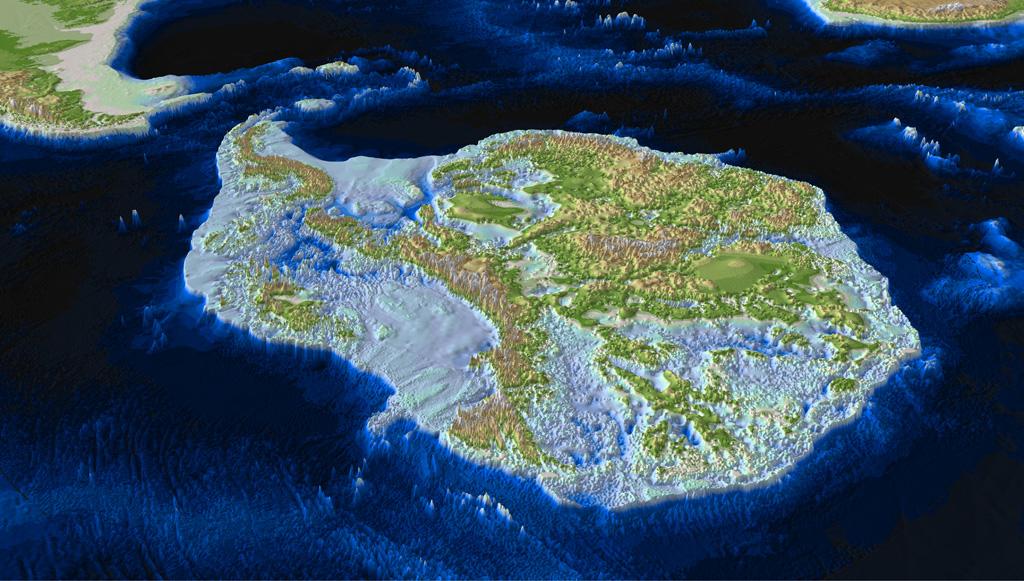
An oblique view of the bed beneath the Antarctic ice sheet with areas below sea level shown as blue, lower areas in green, and mountainous areas in brown and white. British Antarctic Survey
http://www.antarctica.ac.uk
New maps of the sub-ice features in Antarctica and the Arctic, featured in the new edition of The Times Comprehensive Atlas of the World published on 25 September 2014, reveal an unseen world of canyons, lakes, trenches and mountains. The 14th edition of the Atlas also includes a new double page map of the Arctic Ocean, which highlights the dramatic long-term decline of Arctic sea ice cover.
The sub-ice maps draw on bedrock data, provided by the British Antarctic Survey, to show physical features which are obscured by ice cover. In the Antarctic, one of the most striking features is the Gamburtsev Subglacial Mountains, which are as large as the Alps but are currently completely covered by ice.
Peter Fretwell of the British Antarctic Survey said:
'This is the first time that the Times Atlas has included a map of sub-ice Antarctica. The map shows details of the rocky bed beneath the massive ice sheets which cover the surface of the continent. Data for this map comes from the recent Bedmap2 compilation, a large multi-national project that merged 50 years of geophysical data to make a seamless model of ice thickness and sub-ice topography.
'It is very important to know how much ice there is and what the topography of the bed looks like, as this is one of the main controls on how quickly ice sheets melt with climate change. The data in Bedmap2 (the Antarctic bedrock survey) is a key component of the IPCC (Intergovernmental Panel on Climate Change) ice-sheet models that try to predict future sea-level rise; as the world warms with ever increasing greenhouse gas emissions Antarctic ice will start to melt and cause global sea levels to rise, but the speed and amount of sea-level rise is very dependent upon the bed-topography under the ice sheet.'
Also featured are the deep subglacial trenches such as the Thiel Trough and the Bentley Subglacial Trench, the latter reaching a depth of 2496 m, one of the deepest points on the continent. The map shows the location of Lake Vostok and Recovery Lakes which exist beneath the ice, and the East and West Lambert Rifts from which ice flows into the Amery Basin.
In addition to maps of sub-ice features, the new edition of The Times Comprehensive Atlas of the World also includes a new map of the Arctic Ocean which provides a comprehensive picture of long-term trends in Arctic sea ice cover. The map shows the average summer sea ice extent from 1981 to 2010 as well as the 2012 record low summer ice extent, which was 45 per cent lower than the 30 year average. The map also shows the most recent minimum extent of summer 2013, 18 per cent lower than the 30 year average.
Arctic sea ice cover grows each winter and shrinks each summer, reaching its minimum extent in September. It is considered by many scientists to be a sensitive climate indicator and they track this minimum extent every year to see if any trends emerge. The National Snow and Ice Data Center (NSIDC), the data source for Arctic sea ice extent, defines it as the area of the ocean having at least 15 per cent sea ice cover.
Walt Meier, research scientist at the Cryospheric Science Branch, NASA Goddard Space Flight Center, said: 'End of summer sea ice extent averages 40 per cent less than it used to be in the early 1980s. The ice is also substantially thinner, about half the thickness on average than during the 1980s. The loss of sea ice results in more energy being absorbed in the Arctic, contributing to amplified warming compared to the rest of the globe.'
The NSIDC Newsroom reports: 'Long term predictions of summer Arctic sea ice extent made by global climate models (GCMs) suggest that the downward trend will likely lead to an ice-free Arctic summer in the middle of the century. GCMs are in overall agreement on loss of Arctic summer sea ice as a result of anticipated warming from the rise in greenhouse gases this century.'
If you want to link to this article then please use this URL: www.sailworldcruising.com/127211