The B&G Report- Volvo Ocean Race - Leg 1's Pitfalls and Challenges
by Mark Chisnell for B&G on 12 Oct 2014
October 11, 2014. Onboard Dongfeng Race Team during the start of the Volvo Ocean Race, Leg 1, from Alicante, Spain to Cape Town, South Africa. Volvo Ocean Race
http://www.volvooceanrace.com
Top Volvo Ocean Race correspondent and analyst, Mark Chisnell writes a regular report for B&G on the current race and trends he sees developing. Here's his first report.
The Volvo Ocean Race is, after all, a round the world race and that part starts on Saturday – Leg 1; Alicante to Cape Town. It’s been a long time coming, but it’s nearly here.
In the coming months we’ll be following the weather, the moves and counter-moves, the big plays and the little flyers right here on the B&G website, with a weekly report posted every Tuesday. And at the end of each leg, B&G will be awarding a prize to the best performing navigator, according to the following criteria:
'The B&G Volvo Ocean Race Navigator’s Prize will be awarded to the navigator who, in the opinion of the judging panel, has made the most effective use of meteorological, oceanographic and geographical information to gain distance on the majority of the fleet.'
The prize and kudos will go to the navigators who best use their craft to make gains for their team mates. Yours truly will be heading up the judging panel, and each week I’ll bring you an analysis of the strategies that have unfolded – or are in play – that might just win big
I’ll be writing for sailors, people who know their port from starboard, and a tack from a gybe. It will also help if you know a low-pressure system from a high pressure one, but if you don’t… these days, there’s always Wikipedia.
So, looking forward to Leg One – where do some of the challenges and the opportunities lie for our seven navigators?
High Pressure Hot House
We’re into the autumn equinox and a time of unsettled weather, but it looks like the first few days will be dominated by high pressure over Spain. So that means the Med will keep its reputation as light and tricky, with potential for someone to get stuck and take a big loss. Or get it right and make a big gain. The route follows the coast, so understanding land effects will be crucial.
Dire Straits
If there’s not much wind, then getting through the Straits of Gibraltar will be tough, as there’s plenty of current running. The channel is only about eight nautical miles wide, so the fleet will still be forced to contend with local land effects, perhaps picking a shore that could see a split and more opportunities for finding a snake or a ladder.
Horsing Around
Once the fleet get out into the North Atlantic, the next big hurdle should be the Azores High – a large high-pressure area named after the island chain. It determines the position of the trade winds, the moderate to strong north-easterly breeze that usually runs from Portugal down the west coast of Africa. If the weather gods are favouring the fleet, they will roll straight out of the Med to find the trade winds blowing strong and hard, and step onto the conveyor belt that will take them to the Doldrums. If not they will find themselves struggling in what used to be called the Horse Latitudes – more light air.
Cloud Warfare
The Doldrums: AKA inter-tropical convergence zone or ITCZ, is a region of low pressure that surrounds the earth roughly at the equator. It occurs because warm, moist air rises, and there’s plenty of that in the tropics. Cooler air from the north and south of the ITCZ is sucked in to replace this rising air, and this helps form the north-easterly trade winds of the northern hemisphere, and the south-easterly trade winds of the southern hemisphere.
This is the big one for this leg, it’s often won and lost here and the navigators will be very focused on traversing the Doldrums efficiently. The trick is picking the thinnest point to cross – usually to the west – but also to get into a good position for the passage to Fernando de Noronha, the rounding mark in the South Atlantic. If you come out of the Doldrums too far west, you’ll end up beating upwind – slow. Received wisdom has it that the sweet spot is historically around 27-28W, but depending on the conditions, anything between 25W and 30W can work.
While the grand strategy involves finding the right place to cross, the battle will also be fought at a micro level – cloud by cloud. All that hot air rising, leads to a lot of thunderstorms and squalls. The navigators will need to read the clouds well to keep the boat moving fast – one bad cloud can cost you the leg. Or even the race.
Go South
The Azores High has a twin sister sitting in the South Atlantic, sometimes called the St Helena High, after the island. High pressure means light wind and so it blocks the direct route to Cape Town. After the scoring gate at Fernando de Noronha, the fleet will probably be to the west of the centre of the high, and the navigators will try to work their way down this side. It’s almost always quicker to head south, around the centre of the high, to look for a low-pressure system to ride east.
Goosebumps and Chills
The Southern Ocean – just the words can give you goosebumps. Wicked storms and depressions swirl west-to-east around the globe, circulating Antarctica with barely so much as a decent sized island to slow them down.
The strategy in the Southern Ocean is always to find a low-pressure system moving east and ride with it. The big opportunity as the boats struggle round the South Atlantic High is to be first to hop onto just such a low-pressure system. It will accelerate a boat east across the South Atlantic, and sometimes take them right into Table Bay.
Psychologically, it’s hard to head due south when the course to Cape Town is not far off due east, but over and over again, this leg has been won by boats that committed hard to the south, found the big waves and the big westerly breezes (not forgetting the cold) and rode them all the way home. It’s a move that’s got prize winning potential.
That’s it for now, we had a great start on Saturday, and I’ll see you back here next Tuesday to look at how the first few days went down.
Here's Volvo OR Race Control's latest update produced four hours after the race start:
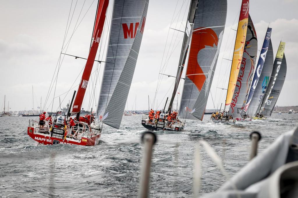
Leader: Mapfre (Iker Martinez). Total spread of the fleet: 4 nautical miles. Bearing: south. Route: straight. Forecast for the night: up to 25 knots with rain showers.
The seven boats are now north of Cartagena, some 150 nm from their next turning point, Cabo de Gata. The Spanish boat is in the lead, 2 nm ahead of Team Brunel, 3 nm ahead of Team Alvimedica, Team Vestas Wind, Abu Dhabi Ocean Racing and Dongfeng Race Team. Team SCA are just behind.
At this stage, it’s all about sailing fast on port tack, minimising manoeuvres, saving energy for the Strait of Gibraltar and the entry into the Atlantic Ocean.
But let’s rewind back a little. Racing started at 1200 UTC with one hour of inshore racing in 10 knots of easterly breeze right in front of Alicante. Helmsmen put on their game face, bowmen ran back and forth to change sails, trimmers grinded like mad men. Hundreds of spectator boats cheered for their favourites, making the atmosphere really warm... and the sea really choppy.
Then the fleet rounded the last inshore mark just outside the harbour. Team Brunel led the charge south, a boat length only ahead of Abu Dhabi Ocean Racing. MAPFRE was following them closely too. The seven teams stacked the sails, gathered in the cockpit and waved goodbyes to the boats nearby, packed with their friends and families.
A couple of hours later, the things have changed already, and it’s a different boat leading. It looks like it’s going to be a long 6,487 nm to Cape Town…
If you want to link to this article then please use this URL: www.sailworldcruising.com/127663