Tropical storm-like conditions in Malta and Sicily as Medicane hits
by Dr. Jeff Masters on 12 Nov 2014
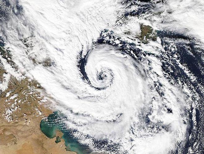
MODIS satellite image of the November 7, 2014 "Medicane" near Malta in the Mediterranean. NASA
http://www.nasa.gov
A rare 'Medicane', a hybrid storm with characteristics of both a tropical storm and an extratropical storm, formed over the South Central Mediterranean Sea on Friday and moved over the island of Malta, bringing them tropical storm-like conditions.
Winds at the Luqa, Malta Airport looked suspiciously like what one would observe with a tropical storm passing overhead--a double peak with a near-calm in between, with the pressure falling to 984 mb during the calm. Winds peaked in Malta at 47 mph, gusting to 66 mph, at 6:37 pm local time, and the island was lashed with flooding rains.
At least one funnel cloud was also observed. A Personal Weather Station (PWS) on the north coast of Malta recorded sustained winds of 69 mph, gusting to 96 mph, with a minimum pressure of 979 mb. Lampedusa e Linosa, Italy, an island between Malta and Tunisa: sustained at 53 mph, gusting to 84 mph. A PWS on Linosa Island recorded a minimum pressure of 982 mb and wind gust to 61 mph.
As of late Friday night, the storm was moving northwards along the east coast of Sicily, Italy, bringing them heavy rain and strong winds.
Is it a hurricane?
Today's Medicane, which has been dubbed 'Qendresa I' by the Free University of Berlin, derived part of its energy from last weekend's Nor'easter that brought early snows to portions of the Eastern U.S., according to TWC's Stu Ostro. So, it got its start from a non-tropical storm, but has definitely acquired characteristics of a tropical storm, making it a hybrid. The NHC does not have responsibility for naming storms in the Mediterranean. If they were responsible, there is a good chance that they would have named this Medicane, labeling it a subtropical storm. A radar loop out of the the Malta Airport Metoffice showed the storm appeared to be forming a banded eye-type structure typical of a tropical storm approaching hurricane strength as the storm moved over the island.
Hurricanes may begin forming in the Mediterranean by 2100
According to research published by Gaertner et al. (2007), an increase in ocean temperatures of 3°C in the Mediterranean by the end of the century could lead to hurricanes forming there. Miguel Angel Gaertner of the University of Castilla-La Mancha in Toledo, Spain, ran nine different climate models with resolutions of about 50 km and found that some (but not all) of the models simulated hurricanes in the Mediterranean in September by the end of the century, when ocean temperature could reach 30°C.
Though the Mediterranean may start seeing hurricanes by the end of the century, these storms should be rare and relatively short-lived for three reasons:
1) The Mediterranean is quite far north and is subject to strong wind shear from jet stream activity.
2) The waters are shallow, and have relatively low heat content. There is no deep warm water current like the Gulf Stream.
3) The Mediterranean has a lot of large islands and peninsulas poking into it, increasing the chances that a tropical storm would weaken when it encountered Click here to read more.
If you want to link to this article then please use this URL: www.sailworldcruising.com/128880