Kwakume Inlet, British Columbia - An excellent all-weather anchorage
by Anne Vipond and William Kelly on 18 Mar 2015
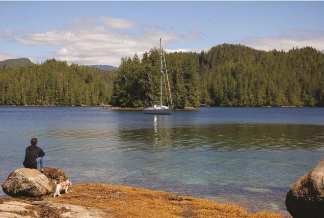
The north end of Kwakume Inlet is quite pretty with a small islet nearby providing the backdrop. Ocean Cruise Guides - Kwakume Inlet, British Columbia Anne Vipond and William Kelly
Having cruised the BC coast for several decades, we enjoy sharing information about the remote northern anchorages we’ve discovered over the years. However, the truth is that we haven’t really 'discovered' many of our favourite spots but were told about them by fellow mariners we have met out on the water – veteran boaters who’ve been more than happy to come aboard for a visit, unfurl a few charts and direct us to some of the best anchorages our coast has to offer.
Our first visit to Kwakume Inlet was thanks to a chance meeting with a fisheries officer in Namu back in the early 1990s. While moored at this abandoned cannery for the night, we got chatting out on the dock with one of the officers from a nearby fisheries vessel who mentioned that an excellent all-weather anchorage in Fitz Hugh Sound is Kwakume Inlet. A few nights previous we had sat out an intense summer storm in Pruth Bay on Calvert Island, and were keen to familiarize ourselves with an anchorage in the area that offered better protection from strong southerlies.
Kwakume Inlet didn’t disappoint. Not only does it provide shelter from a storm, it has everything we look for in an anchorage – scenic vistas, plenty of room for boats to spread out, and good holding ground. The only negative is the large rock lying 200 yards outside the inlet’s entrance. Although there is enough depth to pass on either side of this obstruction, we prefer the north side because of the small peninsula jutting out from the mainland that serves as a navigational landmark.
Once inside the inlet, we like to anchor near the head where a forested islet is good for dog walks, as is the broad foreshore lying opposite with its combination of boulders, sand and gravel. A large rock dries six feet south of the islet and is a popular place for seals parking themselves at low water. After keeping a close eye to the chart to avoid this hazard, we drop the hook in 16 to 20 feet southwest of the islet. The view from here, looking west, is of the distinctive peak of Mt. Buxton on Calvert Island.
While anchored here in fair weather, our teenaged boys have enjoyed dinghy sailing in the afternoon breeze or rowing to the nearby islet. Exploring by motorized dinghy is also interesting, with a hidden beach located in a bight on the inlet’s north shore, just inside the entrance.
The lagoon at the head of the inlet has some flat rocks at its entrance, which make it an ideal picnicking spot. We wouldn’t recommend the lagoon as an anchorage, however. Gusts blow through here during strong northwesterlies and the entrance has less than a metre of depth at low water. It’s fun to enter by dinghy, but one of our most memorable small-boat excursions in Fitz Hugh Sound was on the Koeye River, about five miles north of Kwakume Inlet.
The shallow bay behind Koeye Point at the mouth of the Koeye River provides good temporary anchorage for anyone interested in venturing by dinghy up the Koeye River, which can be navigated all the way to Koeye Lake on a high tide. The bay behind Koeye Point had long been used by local fishermen and kayakers when a contentious sportfishing lodge was built here on a private lot in 1996. Five years later the lodge was purchased by several conservancy societies in partnership with the Heiltsuk Nation, based in Bella Bella. The lodge, which became part of an educational youth camp, was destroyed by fire in 2011 and is being rebuilt.
We learned about the Koeye River from the same fisheries officer in Namu who recommended Kwakume Inlet as an overnight anchorage. He and his crew were heading to the Koeye River to monitor salmon stocks, and the next morning a float plane landed at Namu to transport three of the officers to Koeye Lake. They left armed with rifles for their hike out along one of the area’s busiest grizzly bear trails.
We left that morning too and arrived at the mouth of the Koeye River an hour later, anchoring in the shallow bay behind Koeye Point. Then we climbed into our cockleshell dinghy, armed with a flare kit and airhorn for our journey into grizzly country. As we slowly motored upstream, our dinghy pushed along by a two-hp Johnson, a fisheries skiff sped past. Swimming beneath us were thousands of pink salmon in numbers so thick they clogged the shallow waters and thumped against the bottom of our dinghy.
The tide was dropping and we eventually caught up with the fisheries skiff, which had stopped and was waiting for the three officers who were hiking out from the lake. As we bobbed nearby in our Galleon dinghy, the driver of the skiff warned us we were in 'wild kingdom' and there were a lot of grizzlies in the area. We thanked him and puttered a bit further upriver, then stopped. All was quiet.
Suddenly, something came charging out of the brush. For a split second we thought it was a grizzly, but it was one the armed fisheries officers, followed by the other two. Wearing hip-waders and stoic expressions, they marched past us in the knee-deep water, climbed into the waiting skiff and sped away. We were left rocking gently in their wake. As the grassy shoreline pressed in on us, we looked at each other and agreed it was time to turn the dinghy around and leave the Koeye River to the grizzles.
The mainland lakes and rivers that flow into Fitz Hugh Sound are prime habitat for grizzly bears that come to feed on spawning salmon, and several provincial land conservancies have been established to protect these watersheds. The Koeye Conservancy was established in 2007 and encompasses two freshwater lakes, the river’s estuary, and extensive wetlands and old-growth forests.
The wild beauty of Fitz Hugh Sound was lost on Captain Vancouver when he surveyed these waters in 1792. This is understandable, for he and his men faced the daunting task of charting a coastline that was not only a labyrinth of winding channels and hidden fjords, but presented miles of mountainous shoreline and impenetrable forest. It also rained a lot that summer. In his journal Vancouver describes the 'torrents of rain, and thick stormy weather from the S.E.' as he and his officers surveyed the Sound’s mainland coast in open longboats. They were often wet, cold and exhausted when they set up camp on shore at the end of yet another dreary day.
The 'very disagreeable' weather put Vancouver in a foul mood as they explored 'as desolate inhospitable a country as the most melancholy creature could be desirous of inhabiting.' He commented that 'the ruins of one miserable hut . . . was the only indication we saw that human beings ever resort to the country before us, which appeared to be devoted entirely to the amphibious race; seals and sea otters, particularly the latter, were seen in great numbers.'
The sea otters observed by Captain Vancouver were hunted nearly to extinction to supply the fur-trading ships visiting the coast, but seals and other marine mammals continue to thrive in the waters of Fitz Hugh Sound. Killer whales and Pacific white-sided dolphins are frequently sighted in local waters, and the sound is a summer feeding ground for Pacific humpback whales.
Wilderness still dominates BC’s north coast and pockets of human habitation remain few and far between. The only monuments to the early explorers are their names on marine charts. Whidbey Point, north of the entrance to Kwawkume Inlet, is named for Joseph Whidbey, Master of the Discovery under Vancouver’s command. Whidbey led one of the survey parties exploring this section of coastline in 1792.
It’s always nice to return to an anchorage years later and find that nothing has changed, except perhaps the weather conditions. When we pulled into Kwakume Inlet last summer during a sunny spell, the place felt wonderfully familiar. The wooded islet looked as appealing as ever, the vista of pyramid-shaped Mt. Buxton was still a soothing sight and our boating neighbours for the night consisted of a fishing vessel anchored inside the entrance and a sailboat that anchored out of sight on the other side of the islet.
The sense of solitude was just as we first found it 20 years earlier and the inlet’s forested shoreline, mirrored on the still blue water, looked postcard perfect. With a dry boat to sleep aboard at night, there are few places we’d rather spend a northern summer.
If you want to link to this article then please use this URL: www.sailworldcruising.com/132571