‘Sea Breezes’ and Why.
by Ken Batt and Bruce Buckley on 27 Feb 2006
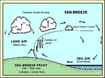
Figure 1 - Sea Breeze Circulation SW
How many times have you been sitting out on the water pondering the key questions about life - such as why the sea breeze refused to show up or, more importantly, had arrived but had rapidly built to a much stronger breeze than you anticipated? How often have you been jogging along a beach somewhere, sweating profusely, but consoled by the knowledge that the local afternoon sea breeze will be making its daily visit very soon to cool you down - without fully understanding just how and why the breeze will arrive?
The answers aren’t that simple because the sea breeze circulation has numerous variations. But we will have a good try at explaining the more interesting features! The information in this article pertains to the Southern Hemisphere and refers to Australia. However, the theory is sound, if reversed, in the Northern Hemisphere.
When we were at school, quite a number of years ago now, we were taught that the sea breeze simply came about because the land heated up during the morning, hot air rose as a consequence and was replaced by cooler air coming in off the water. This movement of cooler air was dubbed the sea breeze. This is OK as far as it goes, but is not a complete enough explanation.
Sure - during most mornings, the sun heats up the land surface; warm air does expand and hence rises. This causes an accumulation of air (an imbalance of pressure) at some higher level, usually between 300 and 1000 metres. Provided there is no significant wind at this level, the air will have a natural tendency to flow seawards to reduce this imbalance. Air gradually subsides or sinks over the sea as it cools, taking the place of the air that is beginning to move towards the coast - the sea breeze. So the sea breeze circulation actually starts above the surface. Figure 1 shows a simplified sea breeze circulation cell.
As time passes by, the circulation increases in extent - both offshore and onshore, and deepens. In pure sea breezes, with a great seawards extent, the greatest temperature gradient is near the coast. More air subsides near the coast, with less further out to sea, leading to a fresher sea breeze near the coast that weakens as you move off shore. Typically you will find the breeze extends out 50 to 60 km offshore by mid-afternoon, with the speed increasing from a few knots at the seaward extremity to 15 to 20 kts near the coast.
The peak speed, usually experienced around mid to late afternoon, depends mainly on the nature of the stability of the air and the magnitude of the temperature gradient between air over the sea and the air over the land, with the former determining the depth of the circulation. During a stable situation, such as that normally associated with the first arrival of a high-pressure system, a shallow temperature inversion can act as a lid on the sea breeze. This means that the upper return flow will be confined to a low height, around 500m, which limits the size of the sea breeze circulation. Thus the sea breeze will be weaker than average, around 10 to 12 kts, and will not extend as far offshore. If there is a reasonably thick layer of flat stratocumulus cloud with the high-pressure system, the sea breeze will be further weakened.
During an unstable weather situation, often with a low pressure system or trough close by, or where we have cold air sitting over a warmer sea, the sea breeze circulation will progressively grow to a height around 900 to 1000m above the surface. This situation, assuming little or no gradient wind (the wind at around 900m above the earth’s surface), is the pure sea breeze situation where the average speed gets up to around 15kt. Here we would see the sea breeze start up mid to late morning as a light wind blowing directly onshore and its direction will shift to the left (or “back”) during the afternoon as the speed increases. This “backing” will tend to be most rapid during the first hour and is largely complete after 2 to 3 hours, although it will continue to back slowly until the sea breeze dies.
The final sea breeze direction ends up blowing along the shore at an angle of about 20 to 30 degrees from the general direction of the shoreline across the southern half of Australia, and 40 to 50 degrees from the shoreline in the tropics where this backing effect is reduced (the Coriolis Effect is weaker). So along the east coast of Australia, including the east coast of Tasmania, it is roughly a northeaster; along western coasts it is a southwester (for example: the Fremantle Doctor); along northern coasts it is a northwester; and on southern coasts the breeze will end up as a southeaster. On some peninsulas, such as North West Cape around Exmouth, two separate sea breezes are experienced. At Exmouth, the north easterly arrives first from Exmouth Gulf, before the stronger south westerly from the Indian Ocean over-runs it.
Once developed the sea breeze is generally very reliable - but there are always exceptions!
Come sunset though, the pure breeze will normally drop off, depending on how quickly the land temperature falls. The drop off will be most rapid near the coast where it was the strongest during the afternoon. A weakening breeze may continue as a cut off circulation that moves away from the coast for a time.
Now that we are full bottle on the pure sea breeze, let’s have a look at sea breeze behaviour under the influence of gradient wind flow - or the flow created by the large high and low pressure systems we can see on a weather map by looking at the isobars.
Following on from the good work performed by Alan Watts, John Simpson and David Houghton from the UK, Frank Bethwaite, from Sydney, adapted the Sea Breeze Quadrants (see Figure 2) to suit the Australian environment. Simply the Quadrant “Theory” proposes that gradient winds blowing offshore at the level of the upper return flow assisted the sea breeze circulation (unless they are so strong that they completely stop the sea breeze), and gradient winds blowing onshore tended to work against the upper return flow and are associated with either no sea breeze or a pseudo-sea breeze flow.
Gradient wind directions in the Southern Hemisphere from somewhere between: the east and the south on a west facing coast; between the south and west on a north facing coast; between the north and west on an east facing coast; and between the north and east on a south facing coast are classified as Quadrant 2 (Q2) winds. Q2 conditions are responsible for the best sea breezes. This breeze will start off in a very similar way to that described above but will attain maximum speeds of between 20 and 25 kts by mid-afternoon, sometimes stronger. By late afternoon the direction of the breeze will be more parallel to the coast than for the pure sea breeze. A Q2 breeze will last a lot longer at the coast, often up ‘til 2300 hr, before cutting off.
When using this technique, care must be taken to observe changes in the weather pattern that can change the quadrant of the gradient wind. For example, along the West Australian coast, there is a trough of low pressure that typically lies very close to the coastline during the warmer months. In the morning, the wind may be blowing quite strongly from the east with the trough offshore. The trough often moves inland by the afternoon, leading to a reinforced sea breeze - as the gradient wind would have moved around to the south east or south south east. In areas from Lancelin to Carnarvon it is not uncommon for sea breezes to blow at 30 knots or more once the west coast trough has moved inland.
A Q 1 breeze (between south and west on an east facing coast; between east and north on a west facing coast and so on) will start up a little later, early to mid-afternoon, than the Q2 case. It won’t be as strong, typically peaking at 15 to 18 kt, and will cut off from the coast about 1.5 hr after sunset. This situatio
If you want to link to this article then please use this URL: www.sailworldcruising.com/21958