
Tracking a manta ray named Leo
by NOAA Fisheries 11 Aug 2019 14:27 UTC
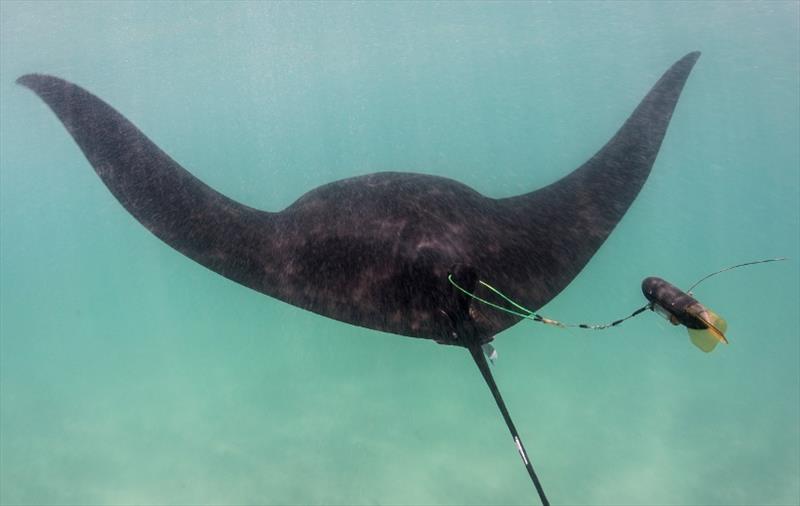
Tracking manta ray Leo © Andrea Marshall / Marine Megafauna Foundation
This summer, NOAA Fisheries and the Marine Megafauna Foundation collaborated on manta ray satellite-tagging expeditions in Southeast Florida. These satellite tags will continuously record location, depth, and temperature.
This information will help us understand their movements and habitat preferences so that we can better protect them.
About Leo
On June 11, 2019, researchers successfully photographed, measured, and attached a satellite tag to a young male manta ray. This manta ray is believed to be a juvenile (sexually immature) based on the small size of his claspers. He measured 8 feet from wing tip to wing tip. Adult manta rays can be reach up to 20 feet across. The tagging team decided to name this manta ray "Leo" after the 3 year old son of an unmanned aerial vehicle (drone) pilot who provides aerial support to researchers on boats.
Leo's satellite tag has been providing high-resolution location data for more than a month now. When Leo surfaces, this data is transmitted back to researchers via satellite. Using this data, scientists are able to track Leo's movements and consider the environmental conditions that may have guided him to a specific location. Scientists hypothesize that sea surface temperature, upwelling, and coastal fronts could be driving manta ray movements.
This information will improve our understanding of how mantas may be impacted by human activities. It will also inform management decisions to mitigate threats, especially in those areas that may provide habitat during important life stages (i.e., mating and nursery habitats).
Follow Leo's movements and track him on this map. Where will Leo go next? And why will he go there? Stay tuned...