
Sailing into the eye of the storm
by Saildrone 2 Jun 2021 10:51 UTC
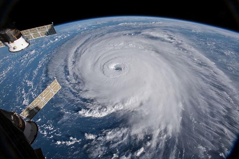
A dramatic view of Hurricane Florence as seen from the International Space Station. A tropical cyclone is a generic term for a rapidly rotating tropical storm with a low-pressure center and clouds spiraling toward the center of the system © NASA Goddard Space Flight Center / Flickr
As hurricane season approaches each summer, coastal communities on the US Atlantic seaboard brace for impact. These fast-moving and often deadly storms aren't only a persistent threat to human safety, they also present a significant economic impact—hurricane damage in the US is estimated at around $54 billion annually.
The biggest challenge to hurricane forecasting is rapid intensification, which can have a huge impact if a storm intensifies just before landfall. Scientists need to understand the ocean processes that are occurring as intensity increases, which means collecting data immediately before and during a hurricane. This summer, Saildrone will sail five uncrewed surface vehicles (USVs) into the eye of the storm.
Saildrone USVs are highly maneuverable, wind and solar-powered vehicles designed for long-range data collection missions. Saildrone USVs are the only autonomous vehicle that can collect meteorological and environmental data above and below the sea surface and withstand the extreme winds and sea state present during a hurricane.
The vehicles will be deployed from the US Virgin Islands and equipped with ruggedized "hurricane wings" designed especially for operating in winds over 70 mph and waves over 10 feet.
"The new hurricane wing is a game-changer for the collection of in situ data in the most extreme weather conditions on earth," said Richard Jenkins, Saildrone founder and CEO. "Saildrone will be able to go where no scientific vessel has ever ventured, right into the eye of the hurricane, and gather data that could make communities around the world safer from these destructive storms."
NOAA's Climate Prediction Center is predicting a 60% chance that the 2021 Atlantic hurricane season will be above-normal, with 13-20 named storms. About half of those are expected to become hurricanes, and 3-5 of those are expected to become major hurricanes, Category 3 or higher.
Saildrone's science collaborators on this mission are the National Oceanic and Atmospheric Administration (NOAA)'s Pacific Marine Environmental Laboratory (PMEL) and Atlantic Oceanographic and Meteorological Laboratory (AOML). The saildrones will be stationed in areas of the Atlantic Ocean that have historically seen a large number of storms. Scientists from PMEL and AOML will work together to pilot the vehicles into a series of hurricanes for testing and sampling. This mission is expected to create a foundation for PMEL and AOML to deploy a larger fleet of saildrones as part of a major field campaign for hurricane observations.
"The biggest gap in our understanding of hurricanes are the processes by which they intensify so quickly, as well as the ability to accurately predict how strong they will become. We know that the exchange of heat between the ocean and the atmosphere is one of the key physical processes providing energy to a storm, but to improve understanding, we need to collect in situ observations during a storm. Of course, that is extremely difficult given the danger of these storms. We hope that data collected with saildrones will help us to improve the model physics, and then, in turn, we will be able to improve hurricane intensity forecasts," explained Dr. Jun Zhang, a scientist in the Hurricane Research Division at NOAA/AOML.
The 23-foot Saildrone Explorer is typically equipped with a 16.5 ft (5 m) rigid wing sail for forward propulsion. This wing is optimized for a wide range of sailing conditions, from very light to moderately heavy wind speeds. In November 2020, Saildrone began a five-month test of the first hurricane wing in an area of the North Pacific where winter storms are frequent.
"PMEL has been working with Saildrone to develop the platform for specific ocean conditions since 2015. Sending a robotic vehicle into the eye of a hurricane, that's never been done before. It's an incredibly complex engineering challenge that could have a significant positive impact on our ability to predict extreme weather, for the benefit of communities facing these events," said Christian Meinig, Director of Engineering at NOAA/PMEL.
The USVs will transmit meteorological and oceanographic data from the eastern tropical Atlantic in real time including air temperature and relative humidity, barometric pressure, wind speed and direction, water temperature and salinity, sea surface temperature, and wave height and period. The data will also be sent to the World Meteorological Organization (WMO)'s Global Telecommunication System (GTS) and disseminated to all of the major forecast centers—some 20 agencies worldwide, including NOAA.
The data will also be valuable to other groups, including the National Weather Service (NWS), and the National Environmental Satellite, Data and Information Service (NESDIS). NWS will use the Saildrone data to improve forecasting. NESDIS will align findings resulting from the Saildrone data with that of other observing platforms, such as gliders.
Saildrone has a proven history of operating successful missions in the world's harshest environments, with over 10,000 days at sea and 500,000 nautical miles sailed from the Arctic to the Southern Ocean. This year, Saildrone will launch several novel missions in the Atlantic, Pacific, and Great Lakes, including a year-round mission to study air-sea carbon dioxide exchange in the Gulf Stream.
Resources:
- "NOAA Predicts Another Active Atlantic Hurricane Season," National Oceanic and Atmospheric Administration, press release, May 20, 2021
- "Expected Costs of Damage From Hurricane Winds and Storm-Related Flooding," Congressional Budget Office, report, April 10, 2019
- "Hurricanes," National Oceanic and Atmospheric Administration, web page, accessed May 4, 2021