Please select your home edition
Edition
2024 fill-in (top)

Saildrone launches first freshwater mission in the Great Lakes

by Saildrone 6 Aug 2021 21:13 UTC
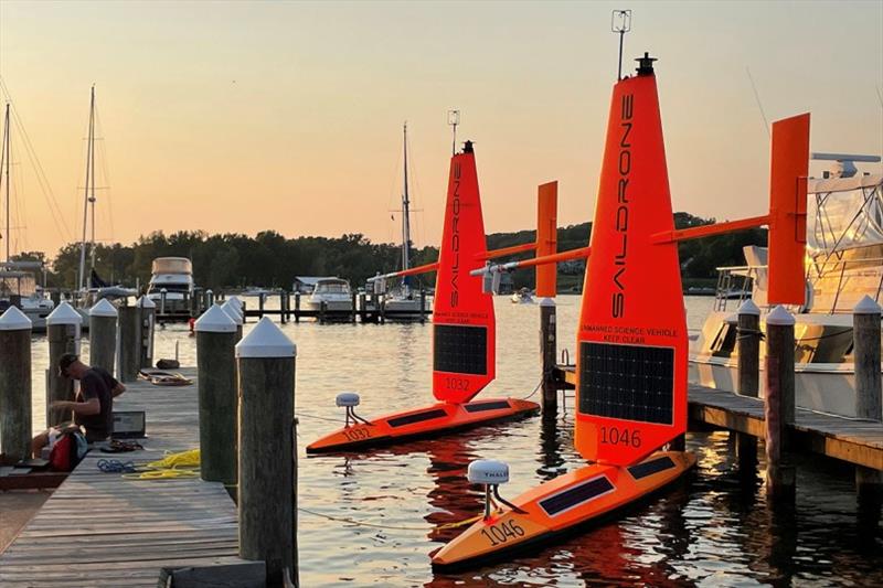
SD 1032 and SD 1046 at the dock in Macatawa, MI, before being deployed to Lake Michigan for the 2021 Great Lakes Fisheries mission © Saildrone

Saildrone's fleet of uncrewed surface vehicles (USVs) has proven its data collection capabilities over seven years of operation from the Arctic to the Antarctic. Now, these ocean drones have entered a new maritime domain - the Great Lakes.

Two Saildrone Explorers were deployed from Macatawa, MI, for a 45-day fisheries mission on behalf of the US Geological Survey (USGS)'s Great Lakes Science Center (GSLC).

While Saildrone has operated missions for scientific data collection, mapping, and maritime domain awareness in every ocean on the planet, this is the first Saildrone mission on any freshwater body.

North America's Great Lakes make up the world's largest freshwater ecosystem. The Great Lakes support a $7 billion commercial and recreational fishing industry, but human-caused and natural changes like degraded habitat, climate, and invasive mussels threaten the health of popular fisheries like lake trout, whitefish, walleye, and northern pike.

The standard Saildrone sensor suite includes science-grade instruments to collect air, sea, and skin temperature, wind speed and direction, relative humidity, barometric pressure, photosynthetically active radiation, salinity, dissolved oxygen, chlorophyll, and wave height and period. Saildrones can also measure ocean current speed and direction and air-sea carbon exchange. While the saildrones collect fisheries data on the Great Lakes, they will simultaneously be collecting meteorological data, which will be used by the National Weather Service to inform weather forecasting.

The vehicles were deployed on July 28, and the mission officially begins today, August 5.

Saildrones are not single-mission vehicles; they are designed for multiple deployments over their long lifespan. SD 1046, one of the two saildrones operating in the Great Lakes this summer, was previously deployed from Saildrone headquarters in Alameda, CA, on the San Francisco Bay to sail across the North Pacific Ocean to the Bering Sea where it performed the 2020 Alaska pollock survey on behalf of the National Oceanic and Atmospheric Administration (NOAA)'s Alaska Fisheries Science Center (AFSC). In 2019, SD 1046 was one of seven saildrones to perform a 60-day fisheries mission along the US West Coast from Cape Flattery, WA, to San Diego, CA.

The second saildrone, SD 1032, was previously deployed to the North Sea for a fisheries mission on behalf of Norway's Institute of Marine Research.

This summer, the Saildrone fleet is simultaneously operating missions in the Pacific Ocean, Bering Sea, and Atlantic Ocean collecting valuable ocean data for climate science, fisheries, and ocean mapping. The 72-foot Surveyor completed its first ocean mapping mission from San Francisco to Hawaii in early July, and a group of Saildrone Explorers equipped with special "hurricane wings" was deployed from Jacksonville, FL, and the US Virgin Islands mid-month to collect data from inside Atlantic hurricanes.

Resources: US Geological Survey, "Sailing Drones Collect Data for Great Lakes Fishery Research," usgs.gov, media advisory, August 4, 2021

Related Articles

Spooky sounds at sea
Listening for bats offshore with USVs There are more than 1,400 species of bats, and bats make up about 25% of all mammals. In North America, bats contribute about $23 billion in pest control services to the agricultural industry. Posted on 26 Oct 2023
Saildrone fleet reaches new milestone
1,000,000 nautical miles and 32,000 days at sea The accomplishment comes just 10 years after the first Saildrone USV crossed the Pacific Ocean and confirms Saildrone's position as the only proven long-range, long-endurance uncrewed platform. Posted on 18 Oct 2023
Explorer SD 1045 entered into Guinness Book
Saildrone Explorer SD 1045 measured the “highest wind speed recorded by a USV” during Hurricane Sam Saildrone Explorer SD 1045 made global headlines when it spent 24 hours inside Category 4 Hurricane Sam, delivering the world's first video footage from inside a major hurricane barreling across the Atlantic Ocean. Posted on 13 Sep 2023
Saildrone sails back into the eye of the storm
SD 1045 is one of 12 saildrones collecting data about hurricane rapid intensification for NOAA Saildrone team—mission managers, pilots, and software and hardware engineers—along with our science partners at the NOAA, anxiously watched as Saildrone Explorer SD 1045 sailed closer and closer to a category 4 hurricane. Posted on 19 Jul 2023
More saildrones deploy for the hurricane season
3rd Atlantic Hurricane mission will provide data to NOAA researchers to better understand the storms The National Oceanic and Atmospheric Administration (NOAA) predicts a "near normal" hurricane season—but it only takes one big storm to cause widespread damage to coastal communities. Posted on 30 Jun 2023
ABS issues first Approval in Principle certificate
To Saildrone, including the first AIP for a 33-foot commercial uncrewed surface vehicle The American Bureau of Shipping (ABS) has issued Approval in Principle (AIP) certificates to Saildrone, including the first AIP for a 33-foot (10-meter) commercial uncrewed surface vehicle (USV), the Saildrone Voyager. Posted on 9 Jun 2023
Capturing the ocean carbon dioxide signal
Societal emissions of climate-warming carbon dioxide have risen year-on-year since the mid-1800s To date, societal emissions of climate-warming carbon dioxide (CO2) have risen year-on-year since the mid-1800s. Over this period, the ocean has absorbed about one third of the emitted CO2 pollution. Posted on 8 Jun 2023
Saildrone scales production of new mid-size USV
Meet the new method for advanced data-collection capabilities at sea To meet the growing demand for advanced data-collection capabilities at sea, Saildrone has developed the 33-foot Voyager designed for near-shore ocean mapping and maritime security missions. Posted on 29 Mar 2023
Saildrone completes Alaska Ocean Mapping Mission
Surveying more than 45,000 square kilometers of previously unknown ocean floor Saildrone surveyed more than 45,000 square kilometers of previously unknown ocean floor around Alaska's Aleutian Islands and off the California coast to address ocean exploration gaps in remote areas. Posted on 9 Mar 2023
Hacking the Anthropocene with Survivalist Robots
New mini-documentary from Freethink* Media's Hard Reset series Saildrone is thrilled to announce this new mini-documentary from Freethink* Media's Hard Reset series! Posted on 17 Dec 2022
Cyclops Marine 2023 November - FOOTERJ Composites J/45Selden 2020 - FOOTER