Please select your home edition
Edition


Extreme Weather Warnings - Don't get caught out!

by PredictWind 23 Sep 2022 04:05 UTC
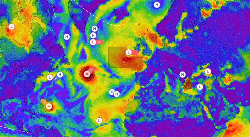
GMDSS Map © PredictWind

When doing a quick check on the weather forecast, it is easy to miss the indicators which can often signal extreme weather, even when the averaged forecasted conditions are benign. To ensure you do not miss these extreme weather events, we now have alerts on the forecast pages and a new GMDSS weather warning overlay on the forecast maps.

PredictWind now uses the following key indicators to alert customers of extreme weather events:

  • Lightning Index
  • Cape Index for Thunderstorms
  • Rain Squalls
  • High Gusts
  • Fog
  • Wind Chill
  • Wind against current
  • Tropical Cyclones
Users are able to see these warnings throughout the PredictWind ecosystem.

Forecast Tables:

The potential for extreme weather is shown in a new row called "Warning". If an event is predicted, it is shown with a warning symbol.

Daily Briefing:

We now have a new field called Extreme Weather, and the relevant warning is displayed when these conditions are forecast.

Forecast Maps & GMDSS weather warnings:

You can now view the GMDSS (Global Maritime Distress and Safety System) weather warnings overlaid on any of our weather maps. The text forecasts are analysed in the PredictWind cloud using machine learning. Then each weather system, front and warning region is plotted accurately on the map, giving you a world-first, global view of the GMDSS forecast.

Weather Routing:

In the weather routing tables, you will see the extreme events marked with a warning symbol. In addition, on the weather routing map, you will also see the extreme events highlighted in orange, ensuring you are alerted to possible extreme weather events. The GMDSS overlay can also be displayed on the weather routing pages.

The extreme weather feature, exclusive to PredictWind, has been created to give maximum safety on the water.

Related Articles

PredictWind powers Cup teams and fans alike
PredictWind has reinforced its status in providing accurate and cutting-edge weather forecasting As the Official Weather Data Supplier for the 37th America's Cup, PredictWind has reinforced its status as a leading authority in accurate and cutting-edge weather forecasting for elite-level sailors. Posted on 28 Aug
Predictwind upgrades ocean and tidal current maps
Predictwind includes an Ultra high-resolution current model for Marseille In the pursuit of continued improvement Predictwind has announced new upgrades to our ocean and tidal current maps. These enhancements are designed to provide users with even more accurate and detailed tidal and current information. Posted on 21 Jul
PredictWind unveils the new PredictCurrent app
The world's most advanced tidal current app This specialized app grants access to incredibly detailed current data, offering an optimized interface for enhanced usability with a quick-view dashboard showing wind, current, waves and tide height all in one place. Posted on 4 May
The Importance of Weather Forecasting
Understanding forecast weather conditions can be crucial to your survival PredictWind is a world-leading weather forecasting tool for boaters. Weather conditions such as storms, high winds, swells and currents can cause havoc for those on the water. Understanding forecast weather conditions can be crucial to your survival. Posted on 1 Apr
Safe routing through the wind, waves, and current
Weather Routing does so much more than get you from A to B In seconds, know exactly what conditions are ahead, how comfortable the route will be, and how to safely and efficiently avoid bad weather, rough seas and shallow water with the world's most advanced routing algorithm. Posted on 19 Mar
Predictwind announce Over the Horizon AIS
Predictwind have released an all new Over the Horizon AIS (OHA) feature on the DataHub Predictwind, the world leading weather information, forecasting and routing service have released an all new Over the Horizon AIS (OHA) feature on the DataHub. Users can view AIS data out to 300nm, directly on your chartplotter and nav apps. Posted on 19 Feb
PredictCurrent: High-res tidal currents model
This groundbreaking solution empowers users to navigate local waters around the globe PredictWind, the leader in maritime weather technology, has announced the launch of PredictCurrent, the world's most comprehensive, high-resolution tidal currents model. Posted on 5 Dec 2023
PredictWind unveils PredictCurrent
The world's most comprehensive, high-resolution tidal currents model PredictWind, the leader in maritime weather technology, announces the launch of PredictCurrent, the world's most comprehensive, high-resolution tidal currents model. Posted on 1 Dec 2023
Predict Wind - Passage planning with PW tools
Having accurate and reliable weather information is paramount to maritime navigation In the world of maritime navigation, having accurate and reliable weather information is paramount to ensure the safety of voyages, whether coastal or transoceanic. Posted on 2 Nov 2023
Free Atlantic Crossing webinar
Part one covered the basics of weather and communications Last week we kicked off our two part Webinar series covering everything you need to know for a successful Atlantic crossing. Posted on 16 Oct 2023