
Saildrone scales production of new Voyager to meet demand for ocean mapping
by Saildrone 29 Mar 2023 11:52 UTC
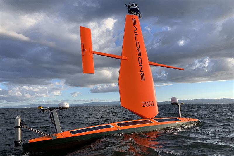
Meet the new Saildrone Voyager USV © Saildrone
To meet the growing demand for advanced data-collection capabilities at sea, Saildrone has developed the 33-foot Voyager designed for near-shore ocean mapping and maritime security missions.
Saildrone, the world leader in providing near real-time maritime intelligence using small uncrewed systems, announced today a new, mid-size class of uncrewed surface vehicles (USVs). The 33-foot (10 m) Voyager is specifically designed for near-shore ocean and lakebed mapping, and to meet the challenges of IUU (illegal, unreported, and unregulated fishing), ISR (intelligence, surveillance, reconnaissance), law enforcement and maritime safety, drug interdiction, and border and harbor security.
Saildrone's three USV models—the Voyager along with the 23-foot (7 m) Explorer and 65-foot (20 m) Surveyor—have been developed to balance mission payload flexibility and endurance. The Voyager's larger size, compared to the Explorer, allows for a more persistent datalink, increased power available for ocean mapping and ISR payloads, and versatile payload integration options.
The ocean mapping sensor suite includes multibeam sonar equipment capable of seafloor mapping of depths to 900 feet (300 m), and the ISR sensor suite includes a smart camera array, digital radar, and sub-surface passive acoustics. Primarily powered by wind and solar, the Voyager also features an electric propulsion alternative, useful for low-wind and near-shore operations.
"With our Voyager platform, Saildrone helps to eliminate maritime gaps above and below the ocean surface, reducing risk to mission and risk to force. We want to be a force-multiplier for our partners and allies when it comes to ISR capabilities," said Richard Jenkins, Saildrone founder and CEO.
To date, Saildrone has built 100 23-foot Explorer-class USVs at its headquarters in Alameda, CA. To meet the increasing demand for the new Voyager platform, Saildrone has elected to outsource the production of the wing, hull, and keel to composite specialists: Janicki Industries will manufacture the wing and keel in Washington, and Seemann Composites will manufacture the hull in Mississippi. Saildrone will continue to produce, install, and service internal components in Alameda.
"One of the truly exceptional aspects of working at a company like Saildrone is the fact that hardware and software engineering, manufacturing, mission operations, and G&A are all housed under one roof—in a former airplane hangar on a site known for aviation and naval innovation," said Saildrone COO Mark Cuyler. "But with the rapidly increasing demand for ocean data collection across the fleet, it is necessary to outsource some of our production. Saildrone is proud to work with great US-based companies like Janicki and Seemann, whose expertise in the marine composites industry will help us to more rapidly meet the demanding challenges of the world's oceans."
Saildrone has been conducting sea trials of the Voyager in the San Francisco Bay and offshore of California since late 2022, and the first operational maritime security and ocean mapping missions will begin this spring. The company is currently producing new Voyagers at a rate of one per week.
The data collection capabilities of Saildrone's autonomous vehicles have been proven in numerous operational missions, covering almost 1 million nautical miles from the Arctic to the Antarctic. The company looks forward to its continued and close partnership with the US Government and its allies in boosting maritime security around the globe.
Visit Saildrone at 2023 IPF, March 28-30, at the Baltimore Convention Center and at the Navy League's Sea Air Space 2023 at the Gaylord National Convention Center in National Harbor, MD.