Please select your home edition
Edition
Sunstorm Marine - Mesh Bag - RIB

Off the beaten path

by Noonsite 2 Jul 2023 22:30 UTC
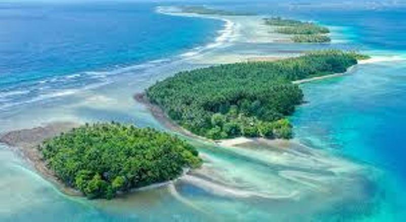
Marshall Islands © Noonsite

The Marshall Islands in the North Pacific is made up of 29 atolls, 5 islands and 1,225 islets which form two major islands chains: The eastern Ratak ('towards dawn') and the western Ralik ('towards sunset') island chain.

Ranked the fourth-least visited country in the world, the Marshall Islands is perhaps the last frontier of yachting, with pristine vibrant ecosystems. Cruising these remote atolls that played a major part in some of the most historical events of the 20th century, requires time, effort and cruising permits, however, it's well worth it, as the crew of SY Alice detail in this report.

Stuck in ice in Greenland for 130 days with his pet chicken, is about as far off the beaten path as you can get with a sailboat. French sailor Guirec Soudée has made headlines with his numerous seafaring adventures, not to mention his unique on board pet - the little red hen Monique. Just sailing from the north to the south pole was not enough for Guirec, who has since rowed across the Atlantic twice and is now working towards an entry into the next Vendee Globe. We review Guirec's new book at the end of the newsletter and you can find out more about this fascinating French sailor and his adventures at guirecsoudee.com.

Watch this free SSCA webinar to get the latest information about NOAA Chart transition from raster to vector format. The webinar also covers satellite charts, especially outside the United States. Longtime SSCA cruisers discuss the use of OpenCPN chart software to create custom Satellite Charts, and satellite chart archives available free of charge to sailors cruising to remote locations around the world.

John and Sue Hacking of SV Ocelot have been publishing charts for years. They have been cruising their Wauquiez Kronos 45 catamaran for over 20 years and their mbTiles charts now cover over 30 countries, including all of the Eastern Caribbean, Galapagos, Micronesia, Solomon Islands, PNG, most of tropical SE Asia, and much of the tropical Indian Ocean. They offer satellite imagery from ArcGIS, Bing (MSFT) and Google Earth, as well as nautical charts from CMap (new, not CM93) and Navionics.

The satellite imagery is incredibly accurate, with max positional errors on the order of 3m (10') and most of them can see underwater reefs to about 10m (33'). The resolution (Z18) is high enough to see individual coral heads, and they are exactly where plotted. The nautical charts aren't as accurate, but they have depths, which are certainly useful. SV Ocelot also show you how to use "Chart Groups" in OpenCPN to switch between charts with only a single keystroke. Cruisers are welcome to download their mbTiles and those with high-quality mbTiles themselves are encouraged to contribute them to Ocelot's repository, so others can download them.

This article has been provided by the courtesy of noonsite.com

Related Articles

Noonsite DAFF survey announcement
Have you sailed to Australia in the last 3 years? The Australian Department of Agriculture, Fisheries and Forestry (DAFF) are currently developing biofouling management options for international non-commercial vessels, so that yacht owners can manage the risks before coming to Australia. Posted on 7 Feb
Mediterranean Sea outlook - January update
The season is well and truly mothballed, noonsite world love to get your feedback Help us expand our Wintering in the Mediterranean report with details of where you have chosen to keep your boat in the off season. Posted on 5 Feb
Atlantic Ocean outlook - January update
How risky is crossing the Atlantic? Planning on cruising the Iberian Peninsula or Biscay next season? Don't miss this free CA webinar, "Understanding the threat of Orcas when sailing", on 11 February at 1930 hrs GMT. Posted on 2 Feb
Formalities Worldwide
What's new for yacht arrivals this month? The Australian DAFF are working towards improving guidance for visiting yachts on Biofouling Management (i.e. what's growing below your waterline) so that yacht owners can manage the risks before coming to Australia. Posted on 1 Feb
Caribbean Sea outlook - December update
The digital ED card system in the BVIs entered an introductory pilot phase on 1 October 2024 Did you know that you can participate in Digital Online Embarkation/Disembarkation (ED) Card Systems to replace the paper arrival / departure cards that travelers file when clearing in and out in some countries? Posted on 3 Jan
Atlantic Ocean outlook - December update
The South Atlantic island of Fernando de Noronha is a convenient first port of entry into Brazil The South Atlantic island of Fernando de Noronha is a convenient first port of entry into Brazil for many yachts crossing the Atlantic from South Africa to the Caribbean. Posted on 2 Jan
Mediterranean Sea outlook - December update
Three months of sailing in Europe can make for a summer to remember Whether you need to fit your Med cruising around work, school, or Schengen zone requirements, three months of sailing in Europe can make for a summer to remember. Posted on 2 Jan
Caribbean Sea outlook - November update
Don't miss the free Doyle Guides App if you are planning on exploring the Caribbean Weather: Caribbean Compass have put together a handy list of updated Caribbean weather websites, nets and services for the 2014/15 season. Posted on 5 Dec 2024
Planning on Cruising in Mexico?
If buying second hand, check for Temporary Import Permit (TIP) registered in that boat's history If you are buying a second hand boat and planning to cruise Mexico, be very careful to check first if Mexico still has a Temporary Import Permit (TIP) registered in that boat's history. Posted on 3 Dec 2024
Mediterranean Sea outlook - November update
The amount of rainfall in the Med this month has been unprecedented Spain: The amount of rainfall in the Med this month has been unprecedented. Posted on 2 Dec 2024
Crewsaver 2021 Safetyline FOOTERHenri-Lloyd Dynamic RangeNoble Marine 2022 SW - FOOTER