Please select your home edition
Edition
Crewsaver 2021 Safetyline LEADERBOARD

Earth Wind Map - with typhoons

by Sail-World Cruising on 8 Oct 2014
SW
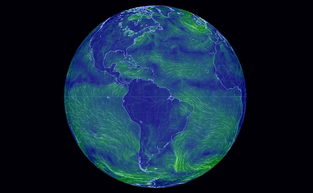
The Earth Wind Map is an amazing project to visualize global weather conditions carried out by Tokyo based software engineer Cameron Beccario, resulting in a beautifully mesmerising depiction of the earth's winds. Weather data is produced by the Global Forecast System (GFS), operated by the US National Weather Service. Forecasts are produced four times daily and made available for download from NOMADS. The files are in GRIB2 format and contain over 300 records.

Formerly a Visual Basic developer with Microsoft Beccario moved to Japan in 2002 and has been developing online trading platforms.

The project, which only went live in December 2013 is the child of a former Tokyo Wind Map project, inspired by the fm/wind map of the USA says Beccario.


The actual map date is provided by Natural Earth, but converted into another format.

In detail, a gentle breeze is shown by a thin strand of green, while strong winds are bright yellow. The strongest currents are bright red.

Users can drag the globe to their desired location and click on the spot they want to find out what the wind speed is.

Users can also zoom in on the currents, which are colour-coded to show the severity of the wind. The detail is quite extraordinary. A region that looks calm at a glance is seen to be rippling with winds on closer inspection, using the mouse wheel to zoom in.


Historical data is available, as is wind data at different heights. This project is a true Work in Progress. Current data has now been added and Beccario continued to work on new features over the last year.

The system also does something else not really seen before. If you ever doubted the existence of the fabled gyres of the oceans, doubt no more. The five gyres can be observed in graphic fluid lines, just as always predicted.

Could you use this for deciding your sailing plans? It is after all taken from GRIB files. It's too early to tell. You decide. However Beccario is at pains to point out that a lot of the data is interpolated.


To access the 'Earth Wind Map', click here. Navigation is a matter of exploration.

If you think you might like to set up your own Earth Wind Map, click here.

Watch the video to learn more about how it works:

Stoneways Marine 2021 - FOOTERGJW Direct 2024 DinghyCrewsaver 2021 Safetyline FOOTER

Related Articles

Bulwarks and Bulldust – watch Episode Six
Are boat shows still Relevant? Episode Six - asks the question, Are boat shows still Relevant? We also offer some thoughts on changes and updates. The final episode of Series One is now live
Posted on 13 Jun
King's Birthday Honours for RNLI lifesavers
Six volunteers and one member of staff, have been honoured by The King Royal National Lifeboat Institution (RNLI) lifesavers with a combined 275 years of dedicated service have been recognised in His Majesty The King's Birthday Honours.
Posted on 13 Jun
Next RYA Connected Webinar on 23rd June
Securing funding and finance for your club If you're interested in securing funding or finance to enable investment for capital infrastructure projects then we think you will want to know about this webinar...
Posted on 13 Jun
Become Pacific plastic hunters this summer
The Ocean Cleanup is calling on sailors out in the Pacific The Ocean Cleanup is calling on sailors out in the Pacific, anywhere between California and Hawaii this summer, to take part in its research expedition to help map plastic in The Great Pacific Garbage Patch (GPGP).
Posted on 12 Jun
PredictWind launches Anchor Alert App
The app delivers immediate, real-time alerts if their anchor drags, ensuring enhanced safety. Global leader in marine weather forecasting, PredictWind, has announced the launch of its new standalone Anchor Alert app.
Posted on 12 Jun
Fountaine Pajot's ODSea+ hybrid electric cats
An environmentally responsible cruising experience without compromising comfort, autonomy or safety Fountaine Pajot has redefined sustainable cruising with the launch of its innovative ODSea+ hybrid electric system across its sailing catamaran range.
Posted on 12 Jun
Introducing EDGE - Your All-Around Advantage
North Sails 3Di Endurance Edge - from Regatta Starts to Sunset Sails North Sails 3Di Endurance Edge - from Regatta Starts to Sunset Sails. EDGE is as ready for regattas as it is for day sailing. Lighter and lower stretch than paneled or string sails. Integrated ENDURANCE Surface™ delivers a durable and easy-to-handle sail.
Posted on 11 Jun
Jazz Turner is now nearing Ireland
Fundraising circumnavigation almost hits the £30k target after just 8 days afloat As at the 10th June Jazz is 8 days out from Brighton, and starting to near Ireland. Jazz had hoped to be further along than this, but the winds have been forcing her to stay close-hauled ever since she started.
Posted on 10 Jun
Ice Memory Foundation opens
The first-ever sanctuary of climate archives in Antarctica As part of the launch of the UN Decade of Action for Cryospheric Sciences (2025-2034), dedicated to the Poles and Glaciers, held in Nice on June 8, 2025, during the 3rd UN Ocean Conference, the Ice Memory Foundation announced two major initiatives.
Posted on 9 Jun
Research Vessel Malizia Explorer Christened
In Monaco by Dr Sylvia Earle and Prince Albert II Team Malizia proudly announces the christening of its sailing research vessel, Malizia Explorer, in a ceremony held this afternoon at the Yacht Club de Monaco (YCM).
Posted on 6 Jun