It's not over - Harvey moving inland
by Jon Erdman and Chris Dolce on 30 Aug 2017
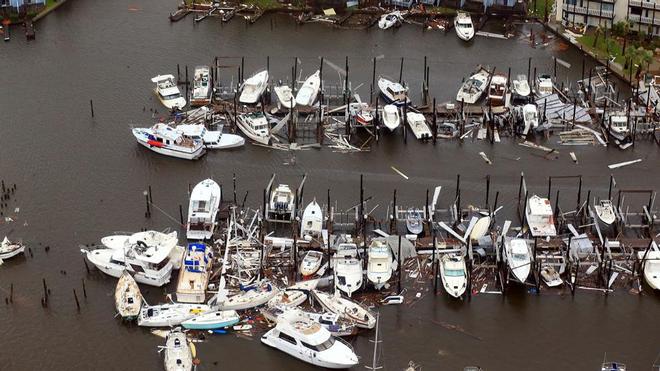
This aerial photo shows a view of damage in the wake of Hurricane Harvey, Monday, Aug. 28, 2017, in Corpus Christi, Texas. Harvey hit the coast as a Category 4 hurricane. Gabe Hernandez/Corpus Christi Caller-Times via AP
Tropical Storm Harvey has set a preliminary Lower 48 U.S. rainfall record for any tropical storm or hurricane as it continues to soak the upper Texas coast and Louisiana, worsening record-breaking, catastrophic flooding. The Cedar Bayou gauge near Highlands, Texas, has reported a preliminary 51.88 inches of rain through 3 p.m. CDT Tuesday. This total may climb higher, as Harvey's rain is not yet finished in southeast Texas.
A Harris County Flood Warning System rain gauge near Friendswood, Texas, reported a four-day storm total of 49.32 inches through 9 a.m. CDT Tuesday. If either of these are confirmed, it would be the heaviest storm-total rainfall from any tropical cyclone in the continental U.S. in records dating to 1950, topping the 48-inch storm total in Medina, Texas, from Tropical Storm Amelia in 1978, according to research by NOAA/WPC meteorologist David Roth.
Suffice to say, this is one of the worst flood disasters in U.S. history, with record-smashing river flooding lasting well into next week.
Through Tuesday evening, parts of southeast Texas have received more than 40 inches of rain since Friday. The top official rainfall total is 43.38 inches at the National Weather Service forecast office in Houston. The average rainfall within the Harris County Emergency Management network has exceeded that of Tropical Storm Allison (2001) in almost half of the time (2 to 3 days versus 5 days).
Houston's Bush Intercontinental Airport crushed its record-wettest calendar day Sunday by over five inches, picking up 16.07 inches of rain, just under the five-day total of 16.48 inches from Tropical Storm Allison in 2001. Houston's Hobby Airport also crushed a two-day rainfall record by almost 8 inches, picking up 23.06 inches of rain Aug. 26-27.
Still a named storm over 96 hours after landfall, Harvey is the longest a Texas landfalling hurricane has remained a named storm after landfall on record, according to Colorado State University tropical scientist Dr. Phil Klotzbach. Harvey made landfall Friday night near Rockport, Texas, north of Corpus Christi, as the first Category 4 hurricane to landfall in the U.S. since Charley in August 2004.
Harvey's center is currently in the far northern Gulf of Mexico accelerating toward the east and eventually northeast. On this track, Harvey's center will make a third and final landfall along the southwestern Louisiana coast early Wednesday. Here's our latest forecast.
Still days of heavy rain ahead
The heaviest rain is now targeting areas near the upper Texas coast east of Houston, as well as parts of Louisiana. Beaumont, Texas, picked up 1 inch of rain in just 26 minutes early Tuesday morning.
Harvey's center of circulation is now just offshore, triggering tropical storm warnings from north of Port O'Connor, Texas, to Morgan City, Louisiana. A tropical storm watch is in effect from east of Morgan City, Louisiana, to Grand Isle, Louisiana.
The tropical storm had been stuck between two areas of high pressure, but will finally make a concerted move northeast later this week, as high pressure over the western U.S. finally weakens and Harvey is steered by high pressure centered near the Bahamas and Florida.
The National Hurricane Center is not expecting a significant strengthening of Harvey while it's briefly off the Gulf Coast, so the main concern should remain additional heavy rainfall.
A tropical cyclone's rainfall potential is a function of its forward speed, not its intensity. Therefore, several more days of torrential rain are expected in many of the already flood-ravaged areas, but Harvey is accelerating which should bring the end of the rain from west to east by midweek in much of Texas.
Areas of heavy rain may persist in parts of Texas or the adjacent lower Mississippi Valley into Friday or Saturday, though the heavy rain threat will be gradually lessening in the most flooded areas by late this week.Here are the latest rainfall forecasts through Friday from the National Hurricane Center and NOAA's Weather Prediction Center:
• Far east Texas into southwest Louisiana: an additional 6 to 12 inches, bringing isolated storm totals up to 55 inches over the upper Texas coast, including the Galveston metro area
• Southern Louisiana into coastal Mississippi and Alabama: storm totals of 5 to 10 inches
• Parts of Arkansas into the Tennessee Valley: storm totals of 4 to 8 inches
Persistent onshore winds are still keeping water levels higher than normal along the upper Texas and southern Louisiana coasts, including Galveston Bay. This coastal flooding may continue through multiple high-tide cycles the next few days, only slowly subsiding with time.
The National Hurricane Center says storm-surge flooding of 2 to 4 feet is possible at high tide along the immediate coast from Holly Beach, Louisiana, to Morgan City, Louisiana, along with storm-surge flooding of 1 to 3 feet from San Luis Pass, Texas, to west of Holly Beach, Louisiana, including Galveston Bay.
These surge-choked bays and inlets won't allow rain-swollen rivers to drain fast enough, backing up these rivers and worsening flooding upstream, just as the floodwater upstream arrives. It will be an arduously slow process to first get coastal water levels down, then drain the massive volume of floodwater upstream. This process will likely continue past Labor Day, in some areas.
For more information on this particular story see here and to keep up with Harvey visit the website.
If you want to link to this article then please use this URL: www.sailworldcruising.com/156835