
Different Drummer Offshore 2018: American Samoa
by Phil Plimmer 4 Jan 2019 14:20 UTC
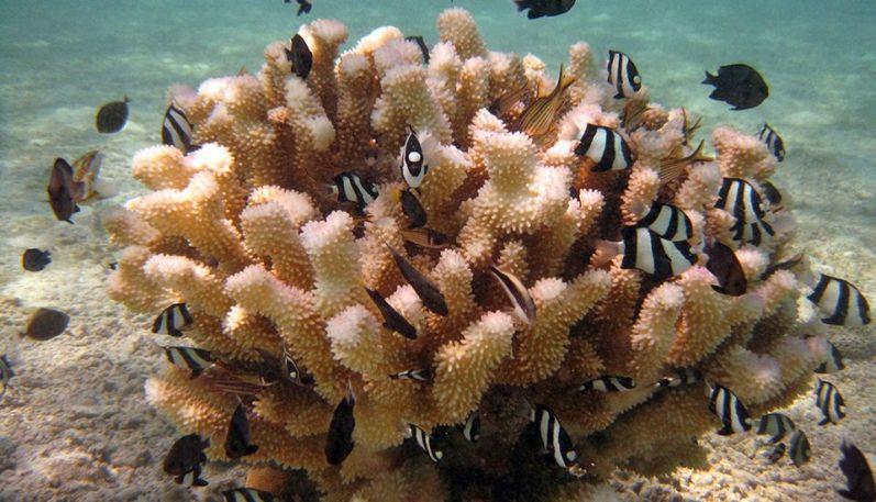
Several species of reef fish nestle in a cauliflower coral in American Samoa © NOAA Fisheries
It was a three day passage from Niuatoputapu to Pago Pago, the capital and port of American Samoa on the main island of Tutuila. It started with good sailing wind on the beam and we put the gennaker up for a few hours but the wind was too far forward for it to be really effective. The wind went soft and forward on the third day and we finished up motoring. A highlight was a double strike of large yellowfin tuna to top up our dwindling fish stock.
We were required to dock at the commercial wharf, rather dirty and yacht unfriendly, and were met by the harbourmaster, very friendly, who guided us through the harbour, customs, agriculture and health clearances. Immigration was not open in the afternoon so we did that the next day. We anchored in the top of the harbour with many other yachts opposite a large diesel power station and near the infamous tuna cannery.
We spent over two weeks in Pago Pago - sightseeing, working on permission to get to Swains Island, doing yacht maintenance, and sampling a few restaurants and bars. At the risk of gross generalisation Pago Pago can be described as a southern USA town dropped into the South Pacific. The local people, predominately Samoan, are very friendly and easy to talk to as they speak English most of the time even when talking to one another. Most things that are not made, grown or caught on Tutuila come from the States via regular shipping and planes through Hawaii. Currency is the US dollar and the population of the island is around 60000. The standard of living is generally high and many families are able to afford and run a late model US utility vehicle.
The privately owned buses are quaint, cute and colourful. They are built locally on a chassis from a retired light truck - 'F' series Fords were popular. All have a high end sound systems blasting music, and some had TV screens showing videos. Fares were $1 for a local trip, and $2 to the other end of the island.
The island is very steep and covered in rain forest with much of the population living on the small flat areas sandwiched between the coast and hills, and the only large flat area, on the southern coast, around the airport. Regular rain keeps the island green, and we had plenty of it while we were there. It kept our water tanks full and hampered our activities on some days.
There was an interesting experience with the antenna for the Iridium satellite phone system we use. I noticed when we got to Pago Pago that reception was very poor and put that down to the steep high hills that surround the harbour blocking the view of the satellites. I later got talking to an American cruiser who loaned (and later gifted) an old spare antenna of a different style he had. Reception immediately returned to normal from which I concluded I had a faulty antenna. I arranged for a replacement to be flown out from the States using the US Postal Service - for a premium you can get things in two or three days with no Customs involvement (other than a parcel inspection at pickup) as it is a 'states to state' delivery. It actually took five days as hurricane Lane had disrupted service through Hawaii. When I installed it I was disappointed that reception was no better than the original one, and I put the gifted antenna back into service. But after we left Pago Pago I put the new one on again and it worked fine. It appears that the initial diagnosis was correct and the type of antenna I use, the recommended one, could not in fact cope with the enclosed harbour. So I suspect I now have three working antennas!
Pago Pago was a very important strategic naval base for the Americans in WWII. Much evidence remains. There were good photographs and information at the National Park display centre. We went to Blunts Point to look at the guns preserved there overlooking the harbour entrance. They reminded me of Stoney Batter on Waiheke, except it was in the jungle. With four small boys who had somehow joined us as guides, we then set off on the WWII Heritage Trail back to Pago Pago. Described as challenging in the guide book it was always steep up or steep down along narrow ridges. We passed numerous concrete structures that you had to use your imagination about what they had been as there were no information signs. At the end there were another couple of large guns in wet pits full of large toads. The boys had fun throwing stones at them; you had to get a direct hit to get them to move. There were also the remains of a cable car that ran right across the harbour to a high peak opposite in the post war era. The cable once downed an Orion aircraft which clipped it when showing off over the harbour on a 'Flag Day'.
One of the other islands that comprise American Samoa, Aunuu, is very small and very close. We took a bus out to a village called Anasi at the eastern end of the main island, and then a small ferry across to Aunuu about a mile away. We found a single village, no shops, a school, and several churches. We walked around the island on roads that started as concrete and finished as four wheel drive tracks. We were accompanied this time by a very friendly young dog that amused us by swimming to cool off everywhere it could find water and trying to catch butterflies. It did catch a fish in the shallow water of a lagoon. We appreciated the shade in the jungle and the breeze on the coast. At the end we met some young men gathering stone off the beach for a house build, and one climbed a coconut tree and got a nut each for us, and one for the dog which enjoyed both the water and meat.
There were tuna boats of various sizes moored alongside the wharf at the cannery, and alongside each other at one end. We walked down the industrial side of the harbour past the large diesel fired power station and the 'Ronald Regan Marine Railway' (which turned out to be a 3000 tonne ship slipway). The tuna factory was spread over four large buildings. It was all behind fences and little could be seen, but a run down the wharf side in the dinghy one day when there were gaps in the boats allowed us to see forklifts transferring tuna sticking out of skips from a boat to the factory.
Leone was the furthest point on the bus route west. We did not realise there was no terminus and the bus came back a different way. We were part way back before we woke up! It was still a good look around that end of the island where it is generally flatter back from the airport with almost continuous villages. We picked one called Nu'uuli where there was a shopping mall and had lunch at Carls Junior. My first time. McDonalds with a different flavour.
Even though the supply routes for most goods to American Samoa are long prices are very reasonable due to few taxes. Fruit and vegetables were readily available although locally grown fruit in the market was largely limited to bananas, paw paw and taro. We enjoyed eating out on a number of nights and tried different styles of restaurants. Our favourite was a Mexican restaurant and bar where we got good food and Busch Ice 5.9% beer for $4 a standard can. The same beer was available in shops at $12 for a box of 12. We also found Coruba rum at $8 a one litre bottle.
I had a minor leg infection from a cut that I wanted cleared up before we left. There are no GPs, but at the hospital it cost $20 for a one-off registration, nothing to see the doctor, and $20 for the prescribed antibiotic.
The telephone service was 4G if you had a 4G capable phone. I found some of our older 'throwaway' phones would not work. The internet was good if a bit flakey holding the connection at times which I put down to my router, the laptop I use, and the email programme not being fully compatible with the service.
We were at Pago Pago long enough to get to know many of the other cruisers there. Americans were dominant, it was sort of like being at home for them, but there were also several Canadians, Europeans, and the occasional Australian. We were the only Kiwi yacht. There was an American catamaran there that had a stay failure and had lost its mast. They had been there a long time getting that sorted and each Sunday evening they generously invited all the other cruisers over for a pot luck dinner. It was the social highlight of the cruisers week.
We wanted to go to Swains Island, a very small atoll which is part of American Samoa a couple of hundred miles to the north. It is a fascinating island with a fascinating history. Barely a mile round it is a donut with a fresh water lagoon in the middle. It was populated for centuries by Tokelau islanders, Solomon islanders, shipwrecked sailors, whalers and latterly supported a good economy based on copra until the market failed. The last people left the island about 10 years ago. The coral reef is beautiful and has been the subject of a Cousteau video. We needed permission from the NOAA National Marine Sanctuary, obtained, and a member of the Jennings family who are the owners of the island, which we had in hand. But the island has no protected anchorage and we also needed a couple days of settled weather. It was there, but always remained a week out of reach. After two weeks we gave up and decided to move on to Futuna.
There was another interesting experience after clearing when we went to lift the anchor. We were very stuck - not unexpected given the number of times we had changed direction in wind shifts while we were there and the reputation of the harbour - it has a lot of debris on the bottom from after the 2009 Samoan cyclone. All our normal tricks did not work so it was out with the Hookah dive unit. I found the chain wrapped several times around a room sized irregular boulder. In an hour on the bottom, shared in rather poor visibility with tyres and ropes, I got all the wraps and tangles out except one. Craig took over but his ears prevented him from getting to the bottom, then Jimmy had a go and even though he struggled to get air (we were working at 10m and the dive gear is rated at 7m) he was able to get the last loop off when we motored forward a little. We finally got away late afternoon. We dodged a small fleet of optimist dinghies as we left the harbour, but were less successful with squalls off the southern coast of the island. Then there was a fishing vessel in our path after dark, quite large, that was not on the AIS and was reluctant to talk to us on the vhf. I turned the spotlight on it and suddenly it all lit up!
By midnight we were well clear of the island and running with a 20 kt easterly behind us in 2.5m swells.
This article has been provided by the courtesy of Island Cruising NZ.