
Magnetic North is moving rapidly towards Siberia
by Daria Blackwell / OCC 18 May 2020 09:16 UTC
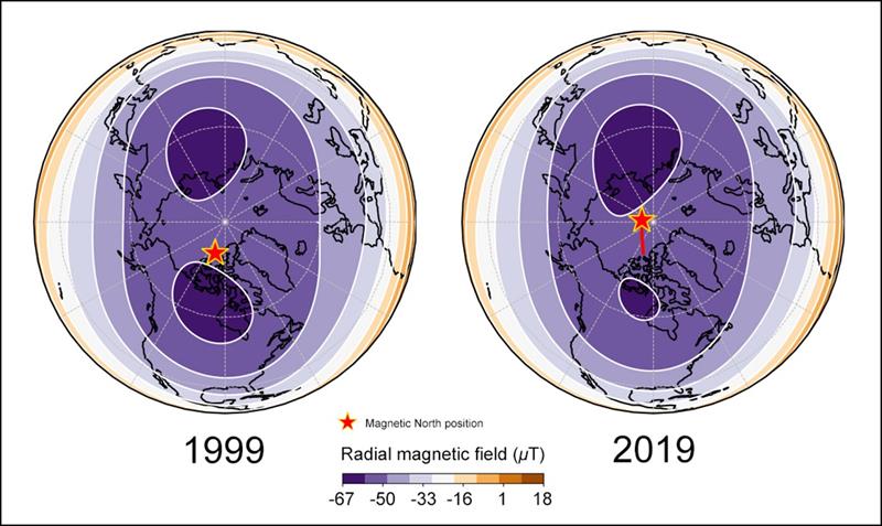
Tug between magnetic blobs pillars © ESA
Scientists think that it's because of elongating blobs of molten metals in the earth's core. This rapid shift is creating a conundrum in modern navigation.
Unlike the earth's geographic North pole which is fixed, the magnetic north pole wanders. Magnetic variation, also known as declination, is the difference between true north and magnetic north. Since it was first measured in 1831, the magnetic north pole has subsequently been mapped drifting slowly from the Canadian Arctic towards Siberia. That's why we have to update charts routinely to account for variation.
For some years now, the north magnetic pole has been picking up speed and has recently been making a rapid dash across the Arctic towards Siberia. Scientists have been studying the phenomenon to try to determine its cause. A paper published 5 May in Nature Geoscience suggests that scientists from the UK and Denmark have mapped the trajectory and proposed a theory about the nature of the forces causing the shifting north magnetic pole.
The researchers believe that two massive elongating blobs of molten iron deep below the surface in Earth's core are at the root of the shifting pole. European Space Agency's Swarm satellite data for earth's magnetic fields showed that the position of the north magnetic pole is determined by a 'tug-of-war' between two large lobes of negative flux at the boundary between Earth's core and the mantle under Canada. Currently, the Canadian flux is weaker shifting the pole toward Siberia. There's no telling where the magnetic pole will end up but they expect it to continue moving towards Siberia over the next decade or so.
Navigators have relied upon the magnetic pole for centuries. More recently, it has become an essential component of smartphone apps and equipment vital to aviation and shipping. The updated version of the World Magnetic Model was released ahead of schedule in January by its joint compilers, the BGS and US National Centers for Environmental Information, to update its location. Together with GPS satellite positioning data, the model underpins modern navigation, and frequent revisions are essential so navigators can reconcile magnetic sensors and compass readings with geographic reality.
The prudent mariner subscribes to the principle of never over-relying on any one method of navigation. I wonder what the migrating wildlife is doing?