Environmental changes in the Arctic put pressure on fisheries data collection and management
by Saildrone 22 Aug 2020 18:14 UTC
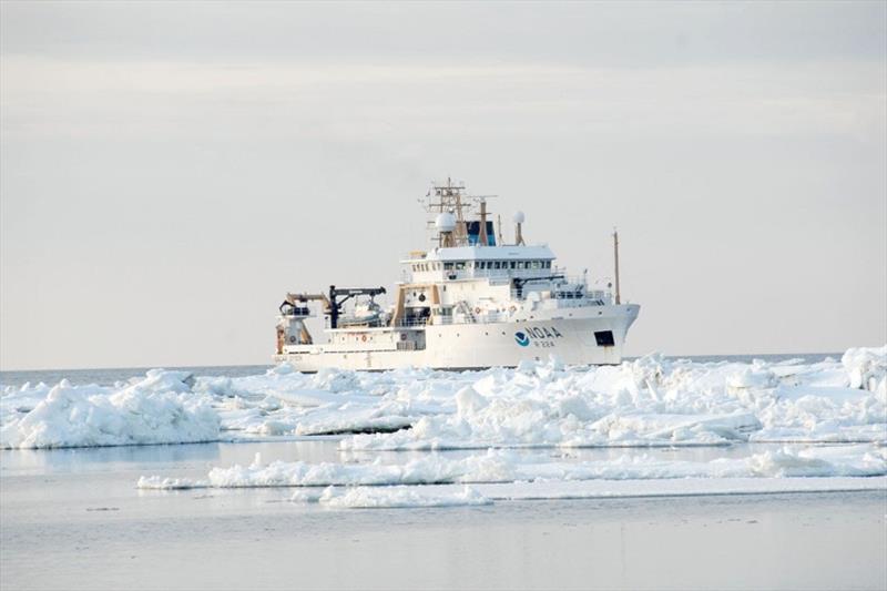
Oscar Dyson is first in a class of ultra-quiet fisheries survey vessels built to collect data on fish populations, conduct marine mammal and seabird surveys, and study marine ecosystems. It operates primarily in the Bering Sea and Gulf of Alaska © NOAA Photo Library
Recent warming events in the Bering Sea have accelerated ecosystem changes that extend throughout the Arctic region, putting pressure on marine resources and the agencies tasked with monitoring the ecosystem and sustainably managing commercial, recreational, and subsistence fisheries and hunting.
Saildrone's fleet of unmanned surface vehicles (USVs) is a cost-effective tool to help fisheries managers meet and expand their mission.
The National Oceanic and Atmospheric Administration (NOAA)'s mission includes conservation and management of coastal and marine ecosystems and resources. The NOAA National Marine Fisheries Service (NMFS) is specifically responsible for the stewardship of living marine resources such as fisheries and marine mammals in US federal waters. The Alaska Fisheries Science Center (AFSC) carries out the NMFS mission in Alaska and the Arctic.
Alaska pollock supports the largest commercial fishery in the US by volume and one of the largest in the world, with recent annual landings of some 1.2 billion kilograms (2.6 billion pounds) valued at well over $1 billion. Alaska has more than 54,000 kilometers (33,000 miles) of coastline—one-third of the nation's total. Overall, Alaska accounts for about 60% of the total US catch, and the seafood industry is one of the largest employers and economic drivers in the state. Other major regional fisheries include Pacific cod, halibut, shrimp, herring, and various species of crab.
"The marine area and the level of economic impact from fisheries in this region are the largest in the US. It's a multibillion-dollar industry. Alaska is also unique because it is home to subsistence communities who have lived here and depended on marine resources for thousands of years," said Robert Foy, the science and research director of the Alaska Fisheries Science Center. "The changes that are occurring in the environment are so rapid, innovative methods for collecting data, such as those that Saildrone is providing and evolving, are more important than ever."
Changes in the Arctic ecosystem
Arctic ice is in constant motion. Sea ice grows and shrinks with the seasons, moving with the winds and the currents. In "normal" years, by March, the ice extends south through the Bering Strait and well into the Bering Sea. Sea ice plays an important role in the Arctic ecosystem: It provides habitat for phytoplankton, birds, and marine mammals like seals and polar bears, and affects the migration routes of whales and seabirds. As sea ice forms, it leaves behind cold, briny water; when it melts, the water becomes less salty. The annual freeze/thaw cycle of sea ice is essential to the health and productivity of the ecosystem.
The Bering Sea "cold pool" is a large mass of frigid water that forms under the ice—temperatures in the cold pool are usually less than 2 degreesC (36 degreesF). The cold pool impacts the distribution of species, acting as a barrier between southern Bering Sea fishes and northern species.
"The Arctic is the canary in the coal mine for detecting climate changes. The changes that we're experiencing on a planetary level are happening first in the Arctic, and we're not talking about it enough," said Foy.
A few years ago, scientists expected that sea temperatures in the Arctic would climb slowly and that, in the future, they'd need to address commercial fish species movement into the northern Bering Sea. But recent marine heatwaves accelerated the process significantly. In 2018, the cold pool was the smallest in the history of AFSC's annual research survey, which spans 40 years. Alaska pollock and Pacific cod extended their habitat north, while key Arctic species, like Arctic cod, were scarce in the northern areas of the Bering Sea where they are commonly found.
The sustainable management of fish stocks is not just protecting the species from overfishing; it's also contributing to the understanding of how environmental changes affect various species in the ecosystem and how those species adapt in turn affects others in the food chain. It also considers how changes in the ecosystem affect people—the fishermen and regional Indigenous communities.
"It doesn't mean the environment will not return to more normal conditions. It might. We might not even be having this conversation a year from now. But this is a glimpse of what's to come, and it's expanded our entire mission," said Foy.
Climbing sea temperatures isn't the only area of concern in the Arctic; scientists have noted changes in CO2 (causing ocean acidification) and oxygen levels. Ocean acidification refers to a reduction in the pH of ocean water and can affect the ability of crustaceans and other calcifying organisms to build their shells. With lower pH, will crabs adapt? Will they move? Or will they disappear? Any one of those scenarios could have a dramatic impact on the ecosystem. Foy says that research conducted at the Alaska Fisheries Science Center shows that pollock and cod are not likely to be as affected by CO2 directly, but their food source might—pollock and cod feed on crustaceans, zooplankton, and smaller fish.
"We need to collect a wide variety of environmental variables, not just temperature and fish biomass. That's where we need to work together with other organizations. If there is a vehicle in the area, regardless of its primary purpose, we need it to be equipped with instruments to collect data," said Foy.
Augmenting ship-based biology to extend coverage
The eastern Bering Sea and Gulf of Alaska, an area twice the size of the eastern seaboard, takes months of ship time to zigzag back and forth during annual surveys. But environmental changes—less ice, warmer waters—mean that some fish have moved some 1,000 kilometers (600 miles) north.
"Our mathematical models need to be able to predict the impacts of these environmental changes so that we can also predict the behavior of the fishermen who will follow the fish. You might not have thought the longline fleet would move 1,000 kilometers north, but they did. In order to effectively manage these fisheries, NMFS has to be there, too," explained Foy.
Saildrone's fleet of autonomous wind and solar-powered vehicles carry a payload of science-grade sensors to collect data above and below the sea surface—air, sea, and skin temperature, wind speed and direction, relative humidity, barometric pressure, photosynthetically active radiation, salinity, dissolved oxygen, chlorophyll, and wave height and period. They can also be equipped with a calibrated split-beam echo sounder to measure fish biomass, a multibeam echo sounder for ocean mapping (bathymetric data is also used to define fish and crab habitat), an Acoustic Doppler Current Profiler to measure ocean currents, or an ASVCO2 to measure atmospheric and dissolved partial pressure of carbon dioxide (pCO2).
Foy says the idea is to use autonomous vehicles to augment ship-based surveys; the saildrones can cost-effectively ease the burden of data collection so that the humans onboard the ships can focus on collecting detailed biological and oceanographic data: "Ideally, you'd have multiple autonomous vehicles sailing in multiple directions, in concert with a research vessel. That's the future. The saildrone allows us to be able to meet and expand our mission better than we're otherwise able to do."
2020 Alaska pollock survey
With several large-scale ship-based surveys in the region canceled due to the ongoing COVID-19 pandemic, scientists at AFSC undertook contingency planning to use saildrones to help fill the gap. The autonomous saildrone made it possible to conduct an acoustic survey and provide some helpful data in a year when it otherwise would not have been possible. The work this year builds off of a five-year collaboration between NOAA's Pacific Marine Environmental Laboratory (PMEL), Saildrone, and AFSC.
Saildrone-based acoustic surveys are well-suited for the Bering Sea because pollock are the dominant fish species there, so scientists can be more confident the vehicle is actually measuring an abundance of pollock and not some other fish species.
"In a year of data collection limitations caused by the pandemic, it's incredible to have this amount of information," Foy noted.
Three saildrones were deployed in mid-May from San Francisco for the 2,000 nautical mile transit to the Bering Sea. Arctic missions usually begin from Dutch Harbor on Unalaska Island, but travel restrictions meant that the vehicles had to be deployed from Saildrone headquarters. After some 40 days at sea, the vehicles reached Unimak Pass and entered the Bering Sea to begin the survey.
Each vehicle took a third of the 600-nautical-mile-wide survey area between Alaska's Aleutian Islands and the western edge of the US exclusive economic zone (EEZ). Based on previous year's surveys, Foy says that while Pacific cod stocks had moved north, Alaska pollock had spread out. The area surveyed by the saildrones represents the footprint of the canceled acoustic-trawl survey.
The saildrones continued to collect other environmental data throughout the survey, some of which were made available to weather forecast centers worldwide via the World Meteorological Organization's Global Telecommunication System (GTS).
All three vehicles have completed their transects and are headed back to San Francisco to deliver the raw data for processing (1-minute resolution data is available in the Saildrone Mission Portal in near real time).
"I was happy that the saildrones made it to the Bering Sea. I was happy to see them make it through the Unimak Pass. The completion of the survey is another milestone win. But as excited as we are, now the crunch time is on. Our analysts need to get the data and turn them around with the expectation that they will be used to inform the management of a major industry in the upcoming fishing year. It's a massive turnaround of information and Saildrone has been phenomenal in terms of what they've promised that they'll be able to do," concluded Foy.
Read more: Saildrone to Perform Alaska Pollock Survey Amid COVID-19 Lockdown
Resources:
- Hal Bernton, "As Bering Sea Ice Melts, Alaskans, Scientists and Seattle's Fishing Fleet Witness Changes 'On a Massive Scale'," The Seattle Times, September 21, 2019
- Warren Cornwall, "Vanishing Bering Sea Ice Threatens One of the Richest US Seafood Sources," Science, May 15, 2019
- Jenna Kunze, "As the Arctic Warms, Alaska Inupiat Adapt," High Country News, July 1, 2020
- H. R. McFarland, J. Prewitt, et al., "Bering Science: Spring 2020 Bering region ocean update," Alaska Ocean Observing System, Issue 1 [newsletter], accessed August 13, 2020
- Jullian Mock, "In 2018, Alaska's Bering Sea Was All Out of Whack," Popular Science, December 28, 2018
- Alaska Seafood Marketing Institute, "The Economic Value of Alaska's Seafood Industry," economic value report, January 2020
- "Autonomous Vehicles Help Scientists Estimate Fish Abundance While Protecting Human Health and Safety," NOAA Fisheries Alaska Fisheries Science Center, June 1, 2020
- National Oceanic and Atmospheric Administration, "NOAA Ramps Up Use of Drones to Collect Fish, Seafloor and Weather Data," NOAA.gov, June 19, 2020
- PMEL Carbon Program, "What is Ocean Acidification?" NOAA.gov, accessed August 19, 2020