Inside the eye of the storm: Saildrone collects live video of Category 4 Hurricane
by Saildrone 2 Oct 2021 06:42 UTC

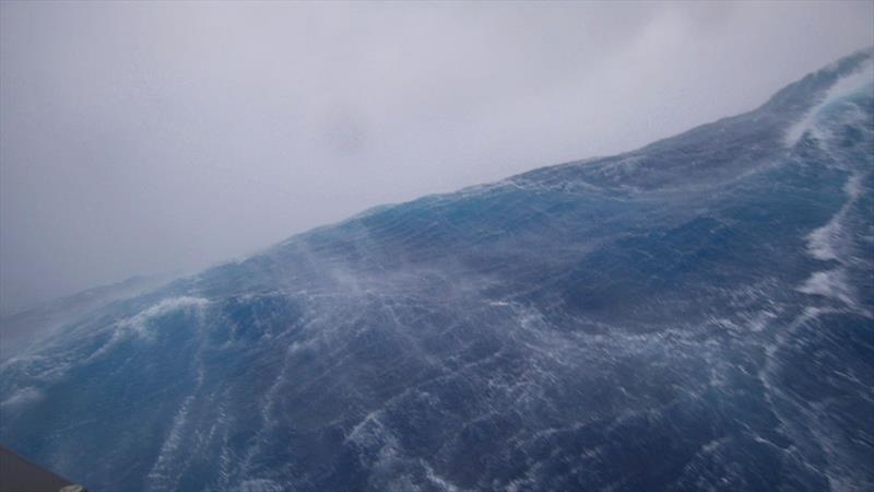
A massive wave captured by SD 1045's onboard camera during Hurricane Sam © Saildrone
In a world first, a 23-foot Saildrone Explorer equipped with a specially designed "hurricane" wing has collected the first video footage of the extreme weather conditions inside a Category 4 hurricane in the Atlantic Ocean. The mission is a partnership between Saildrone and the National Oceanic and Atmospheric Administration (NOAA). Five vehicles were deployed to better understand the ocean processes that are occurring as hurricane intensity increases, which means collecting data immediately before and during a hurricane.
Hurricane Sam was upgraded to a Category 4 storm by the National Weather Service as SD 1045 reached the storm. At the time tie video was collected, the saildrone was experiencing winds gusting over 120 mph and 50-foot waves. Hurricane Sam is currently on a path that fortunately will miss the US East Coast, however large tropical swells could cause life-threatening surf and rip current conditions. The data it is collecting is giving us a completely new view of one of Earth's most destructive forces.
"Saildrone is going where no research vessel has ever ventured, sailing right into the eye of the hurricane, gathering data that will transform our understanding of these powerful storms," said Richard Jenkins, Saildrone founder and CEO. "After conquering the Arctic and the Southern Ocean, hurricanes were the last frontier for Saildrone survivability. We are proud to have engineered a vehicle capable of operating in the most extreme weather conditions on earth."
SD 1045's "hurricane wing" enables it to operate in extreme wind conditions. The saildrone is braving Hurricane Sam in the open ocean, collecting real-time observations for numerical hurricane prediction models, which are expected to yield new insights into how large and destructive tropical cyclones grow and intensify. This knowledge is critical to improving storm forecasting and is expected to reduce loss of human life by allowing better preparedness in coastal communities.
"Using data collected by saildrones, we expect to improve forecast models that predict rapid intensification of hurricanes," said Greg Foltz, a NOAA scientist. "Rapid intensification, when hurricane winds strengthen in a matter of hours, is a serious threat to coastal communities. New data from saildrones and other uncrewed systems that NOAA is using will help us better predict the forces that drive hurricanes and be able to warn communities earlier."
The saildrones provide data directly to NOAA's Pacific Marine Environmental Laboratory (PMEL) and Atlantic Oceanographic and Meteorological Laboratory (AOML), Saildrone's partners in this mission.
The vehicles were deployed in June from Jacksonville, FL, and the US Virgin Islands, and are stationed in five key areas of the Atlantic Ocean that have historically seen a large number of storms. Scientists from PMEL and AOML will work together to pilot the vehicles into a series of hurricanes for testing and sampling. This mission is expected to create a foundation for PMEL and AOML to deploy a larger fleet of saildrones as part of a major field campaign for hurricane observations.
All five saildrones used in the mission are transmitting meteorological and oceanographic data from the eastern tropical Atlantic in real time including air temperature and relative humidity, barometric pressure, wind speed and direction, water temperature and salinity, sea surface temperature, and wave height and period. The data will also be sent to the World Meteorological Organization (WMO)'s Global Telecommunication System (GTS) and disseminated to all of the major forecast centers—some 20 agencies worldwide, including NOAA.
The data will also be valuable to other groups, including the National Weather Service (NWS), and the National Environmental Satellite, Data and Information Service (NESDIS). NWS will use the Saildrone data to improve forecasting. NESDIS will align findings resulting from the Saildrone data with that of other observing platforms, such as gliders.
Saildrone has a proven history of operating successful missions in the world's harshest environments, with over 10,000 days at sea and 500,000 nautical miles sailed from the Arctic to the Southern Ocean. This year, Saildrone will launch several novel missions in the Atlantic, Pacific, and Great Lakes, including a year-round mission to study air-sea carbon dioxide exchange in the Gulf Stream.