
Saildrones launched in Lake Superior to support $7B Great Lakes fishery
by Saildrone 11 Aug 2022 18:34 UTC
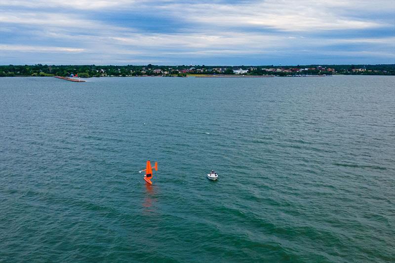
SD 1064 deployed from Ashland, WI, into Chequamegon Bay, on the southwestern shore of Lake Superior © Don Jaskowiak
North America's Great Lakes make up the world's largest freshwater system and are one of the most ecologically diverse ecosystems on Earth—home to nearly 139 native species of fish.
The Great Lakes commercial, recreational, and tribal fishery is valued at $7 billion annually and adds more than 75,000 jobs to the economy. The status and trends of Great Lakes fish stocks are assessed to support management decisions in the face of numerous threats including degraded habitat, changing climate, declining productivity, and invasive species.
This week, Saildrone launched two uncrewed surface vehicles (USVs) on a large-scale, multi-partner mission in Lake Superior supporting the sustainable management of the Great Lakes fishery. Led by the US Geological Survey (USGS), the 25-day mission brings together state, federal, tribal, Canadian provincial, private, and non-profit partners using advanced fishery research approaches to enhance fishery assessment methods.
USGS, in partnership with the US Fish and Wildlife Service (FWS), the Michigan Department of Natural Resources (MDNR), and other agencies use underwater echo sounders to conduct surveys to estimate the abundance of fishes from large research vessels. However, regional fisheries experts suspect the noise produced by those diesel-powered boats may scatter the fish, resulting in inaccurate stock counts.
The 23-foot Saildrone Explorer carries sensors to measure fish distribution and density data around the clock. The saildrones, which have a zero operational carbon footprint and operate virtually silently, will enable USGS scientists to better understand the effects of large vessel engine noise on fish sampling and catchability.
SD 1063 is one of two Saildrone Explorers deployed to Lake Superior this summer. Video: Don Jaskowiak.
"The USGS strives to continuously enhance the quality of our science by integrating cutting-edge technologies into our research," said Peter Esselman, a USGS biologist and the project lead. "The data collected during this Lake Superior mission will help Great Lakes fishery managers make the most informed decisions possible to sustain the fishery."
Estimation of prey fish abundances in the Great Lakes is a central part of the USGS Great Lakes Science Center (GLSC)'s annual commitments to fisheries managers throughout the Great Lakes. The saildrones will also provide supplemental data on the abundance of rainbow smelt, an invasive prey fish species that has become thoroughly integrated into Great Lakes food webs.
"Saildrone uncrewed surface vehicles (USVs) have already sailed 800,000 nautical miles and spent 18,000 days at sea—and counting—collecting data to serve a wide range of research objectives, from seafloor mapping and maritime security to climate science and sustainable fisheries management. Sustainable fisheries management is imperative not only for the long-term health of the fisheries but for the Great Lakes ecosystem as a whole," said Matt Womble, Saildrone director of ocean data programs.
This is the second year of a four-year project to study the effects of vessel noise using two Saildrone Explorers equipped with fisheries echo sounders. Last summer, two Saildrone Explorers were deployed from Holland, MI. They spent some 45 days surveying Lake Michigan and Lake Huron, gathering fish distribution and density data.
The Saildrone USVs conducted independent surveys and coordinated comparative surveys with three research vessels and assessed fish stock distribution during the day vs. at night, and inshore vs. offshore.
The Saildrone Explorer is a proven platform for acoustic fisheries surveys, having performed numerous fish stock assessments in the Arctic, along the US West Coast, and the North Sea. Powered by wind for propulsion and solar energy to run onboard instruments, Saildrone USVs have demonstrated their capabilities around the world, from lakes, to the treacherous Southern Ocean to the eye of Atlantic hurricanes.