
With soaring temperatures and extreme weather events, ocean data has never been more important
by Saildrone 25 Aug 2022 19:25 UTC
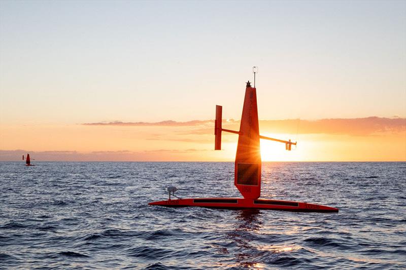
Two ocean drones are collecting data in the Gulf of Mexico to help monitor weather and the impact of climate change © Saildrone
With life-threatening heat waves experienced around the globe and the hurricane season upon the US, access to ocean data has never been more critical.
The ocean environment is a key driver of weather patterns on land. Unless we understand our oceans, the insights we can gain about our changing climate and its impact on humanity are limited.
To ensure the flow of ocean data continues uninterrupted for weather forecasting, Saildrone, in collaboration with the NOAA's National Data Buoy Center (NDBC), is sending two uncrewed surface vehicles (USVs) into the Gulf of Mexico to collect data in two areas currently experiencing buoy outages.
The NDBC has over 200 moored weather buoys collecting ocean data around the globe. Maintaining the network of buoys and all their sensors is a big job that requires experts to travel on ships for weeks at a time far from shore to reach and repair the buoys. Two weather buoys in the middle of the Gulf of Mexico are slated for repair in the coming weeks. Until they are back online, Saildrone USVs will collect and send ocean data to the NDBC beginning on August 22, 2022, which will be shared with climatologists and weather forecasters around the world via the Global Telecommunication System (GTS).
The ocean covers 70% of the earth's surface, so climatologists use the limited ocean observations they can obtain to estimate measurements for near and longer-term global forecasts. These forecasts are important and serve many purposes ranging from ocean conditions and hurricane prediction to maritime safety for the shipping industry, which transports 80% of goods around the globe, providing jobs for almost 650,000 Americans, and $150 billion in annual economic output.
"We are excited to establish this partnership with Saildrone. These two stations in the central Gulf of Mexico, 42001 and 42003, have operated in the same locations for almost fifty years, providing a critical long-term climatology record of atmospheric and oceanographic conditions," said William Burnett, Ph.D., director of NOAA's National Data Buoy Center. "At times when these deep-ocean stations stop reporting, the ability to quickly send uncrewed vessels to mitigate the outage until we can service the platforms is essential. Saildrone has been partnering with us to explore new ways to leverage technology to collect this data in a safe and sustainable manner. There are large amounts of the ocean still unobserved with in-situ atmospheric instrumentation, expanding the marine observation network will dramatically improve weather and ocean warnings and prediction."
"NDBC performs a critical role in the monitoring and prediction of global weather patterns," said Matt Womble, Saildrone director of ocean data programs. "We are excited to be taking part in this mission and look forward to demonstrating the value Saildrone can bring to the sustainable collection of more ocean data in the future."
The Saildrone Explorer is a 23-foot wind and solar-powered uncrewed surface vehicle (USV) designed to collect high-resolution ocean data in remote areas of the ocean while creating a zero-carbon footprint. Saildrone USVs are deployed and recovered from any oceanside dock and are designed to fit into a shipping container for transit to any launch site. Once launched, they can make their own way to the area of study, returning to port at the end of the mission.
The capabilities of Saildrone USVs make them an ideal solution to quickly mitigate outages within moored buoy networks, particularly in more remote areas of the ocean, and dramatically increase observations in large data sparse regions of the ocean.
Saildrones can sail to regions that are not instrumented, stay in the desired location for up to 365 days, and then return to port for maintenance and sensor calibration. This eliminates the need for large, crewed ships to travel hundreds of miles into remote or dangerous waters, both improving maritime safety and decreasing costs associated with additional ocean data collection.