
When will Antarctica's ice cliffs come crashing down?
by The Woods Hole Oceanographic Institution 20 Nov 2022 07:37 UTC
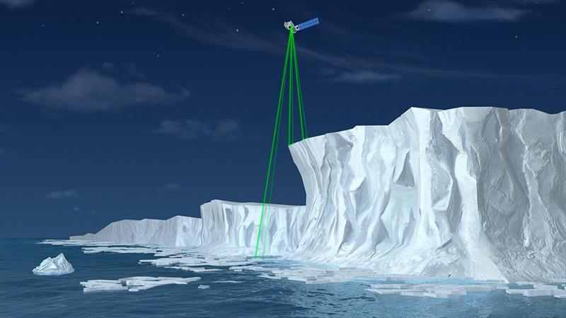
Illustration of NASA's Ice, Cloud and land Elevation Satellite-2 (ICESat-2) © NASA
As increased warming in Antarctica causes glaciers to retreat and shed their increasingly-unstable shelves, towering walls of ice are left looming high above the sea. But how tall these rugged cliffs actually grow before they come crashing down has been a question for glacial scientists—and one that has important implications for sea-level rise.
"There's a theory out there that says ice is only so strong, so it can only ever reach a certain height before it breaks apart," says WHOI assistant scientist Catherine Walker, who studies the dynamics of ice on Earth and in space. "In the case of ice cliffs, the general assumption has been that a cliff can only grow to roughly one-hundred meters—just slightly higher than the Statue of Liberty—before it collapses under its own weight and falls into the ocean."
The theory, it turns out, stems from research that University of Michigan professor Jeremy Bassis and Walker conducted a decade ago. They had come up with some relatively straightforward calculations and combined those with estimated heights of ice cliffs that had been observed in existing ice shelves to settle on the 100-meter figure.
Surprisingly, no one has ever actually surveyed the height of ice cliffs around the continent, according to Walker. Yet, sea-level rise models, and predictions for how high seas will rise, are largely based on this 100-meter threshold figure.
"In reality, we don't actually know when an ice cliff will collapse," says Walker. "It's currently one of the biggest sources of uncertainty in sea-level predictions."
In Antarctica, these magnificent cliffs collar the edges of the ice sheet. Paired with floating ice shelves, they hold in all the ice sitting in the middle of the continent like a cork that keeps it from flowing into the ocean. If, in the near future, ice cliffs begin to collapse rapidly, the interior of the ice sheet will start to get eaten away faster and faster (called runaway collapse), which could contribute as much as six feet of sea-level rise by 2100, according to some models.
"This is where a lot of the scary news reports come from that talk about what could happen if all of West Antarctica suddenly disintegrated," says Walker.
Fortunately, the height of these ice cliffs can be measured with help from a NASA satellite designed specifically for the topographical profiling of ice. The so-called Ice, Cloud and Land Elevation Satellite-2 (ICESat-2), launched in 2018 as part of NASA's Earth Observing System, measures ice sheet elevation and sea ice thickness by shooting ribbon-like lasers down at the Earth roughly every three months.
"There happens to be pretty good satellite coverage in Antarctica," says Walker, who recently received funding from NASA to begin processing the ICESat-2 cliff height measurements. "The data should help us find if and where [cliffs] are threatening to collapse imminently, which in turn will tell us more about how quickly sea levels will rise," she says. "If we find, for example, that most or all of the cliffs are less than 100 meters high, they will still contribute to sea-level rise, but likely at a slower rate than expected."
Bassis, who is collaborating with Walker on this project, says he's excited that the 100-meter ice cliff theory is being revisited. It will allow for the input of more "empirical constraints" into models to make better predictions as to when the cliffs are likely to collapse—and how quickly, he says.
"What Catherine is doing here is really important as it gives us a chance to revisit the work we did ten years ago with a whole bunch more data and a much more sophisticated modeling approach," says Bassis. "It's always interesting when you can go back and test your own hypotheses—particularly when you're not sure the current theories are right."
Beyond their analysis of cliff height measurements, Walker and Bassis plan to use ICESat-2 data to map crevasses (i.e., cracks) within the glaciers. "The strength of the ice may depend on how big these crevasses are, so this will give us a much more quantitative way to figure that out," says Bassis.
Satellite measurements aren't perfect, however, and there are gaps between the laser measurements that ICESat-2 traces over the ice. "You have something way up there measuring stuff way down here," Walker puts simply.
To increase the spatial coverage in the future—and ground truth the satellite measurements—Walker hopes to someday soon have aerial drones that shoot lasers down from right above the cliffs. But for now, ICESat-2 is shining an unprecedented light on Antarctica's coastline.
"The results of this study could help rewrite the story of not only what the height threshold should be for ice cliffs, but what their actual contribution to sea-level rise might look like in the future," says Walker.
Funding for this research is being provided by NASA's Cryosphere Program, grant 80NSSC22K0380.
This article has been provided by the courtesy of Woods Hole Oceanographic Institution.