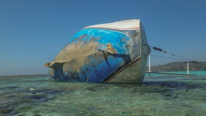
Fred Again III - Lost on Reef in the Caribbean
by Rob Murray, BCA 29 Apr 2019 15:32 UTC

Fred Again III - Lost on Reef in the Caribbean © Rob Murray / BCA
I wrote for Currents about Navionics and the sonarcharts feature they enabled a few years ago (see article on page 28). Here's an update from an incident in Roatan, Honduras in February 2019.
Essentially, Navionics collects data from users and adds it to existing charts with a proprietary algorithm to enable additional detail, or detail where there was none before, and calls this 'sonarcharts'. In the areas we have been cruising, we have seen a marked increase in chart details and soundings, much to our delight. Combined with the 'community layer' (where users add details like rocks, points of interest, way points, etc. for the use of others) and the 'active captain' layer (similar to the community layer), e-charts did improve markedly. We have used the feature extensively ourselves, and found it was usually very good. In our experience, there has been no failure.
However, it seems it doesn't always work as desired. Fred Again III, a C&C captained by Robert Nuttall, was using the sonar charts layer as their primary charting system on approach to Roatan, and found the data sorely lacking. Nuttall had sailed from Vancouver BC down the coast and through the Panama Canal and had come to rely almost exclusively on the Navionics with sonarcharts for plotting. He had found it 'spot on' in his voyages and it had never let him down before. He had no reason to doubt its accuracy here.
Approaching Roatan at 2200 hours (after dark), he planned to use the chart to enter the anchorage in Little French Cay. The sonarcharts showed an open approach with minimum depths of some 15'. The Navionics or government charts showed the reef as shallow (too shallow to pass over), but did not show the true extent of the reef. Using either set of charts, or paper charts, would have delivered the same result, as all showed deep water where he went aground on the reef.
It appears the algorithm used to add new soundings and integrate them with the existing soundings interpolated the depths inside and outside the anchorage, 'smoothing' them to create a false pass over the reef where none existed. It also displayed soundings that were obviously incorrect over the reef. How this was possible I do not know. Combined with the inaccurate charting of the reef on the underlying hydrographic survey, it created the conditions for a disaster.
Now clearly, there were additional precautions he could (and should) have taken. He was after all approaching an unknown harbour at night, one with coral reefs. Prudence dictated staying offshore, perhaps a mile or more, until dawn and using Mk.1 eyeballs as additional aids to navigation to pilot an entry. If he had access to and had used a program to capture and display Google Earth images (like OpenCPN with the GE2KAP add-on, SASPlanet, or Ovitalmap), he could have confirmed chart details were in error with another source (Google Earth images are very good at displaying reefs). A cruising guide could have described the entrance and hazards, perhaps better than the charts. Radar might have shown the reef, but he did not have radar, and it is not always great at showing reefs. But those ideas aside, he was severely let down by the charts, which all mis-charted the extent of the reef by some 600', and in the case of the 'sonarcharts', showed an entrance to the anchorage that simply did not exist.
The captain and crew of Fred Again III were rescued without injury, but the boat is a total loss, will have to be removed at the owners expense and has suffered looting.
As always, mariners are cautioned not to rely on any one source of information, and to use all means at their disposal to make safe passages and landfalls. Aboard Avant, we will continue to use Navionics with the sonar chart feature, but we will use other charts more diligently, and Google Earth images as well.
The CBC featured an article about Fred Again III. Nuttall has a go fund me campaign set up to help him get back on his feet. He also maintains a blog if you are curious to read more about his adventures.
This article has been provided by the courtesy of Bluewater Cruising Association.